Wednesday, November 15, 2017

The Worst Natural Disaster in U.S. History


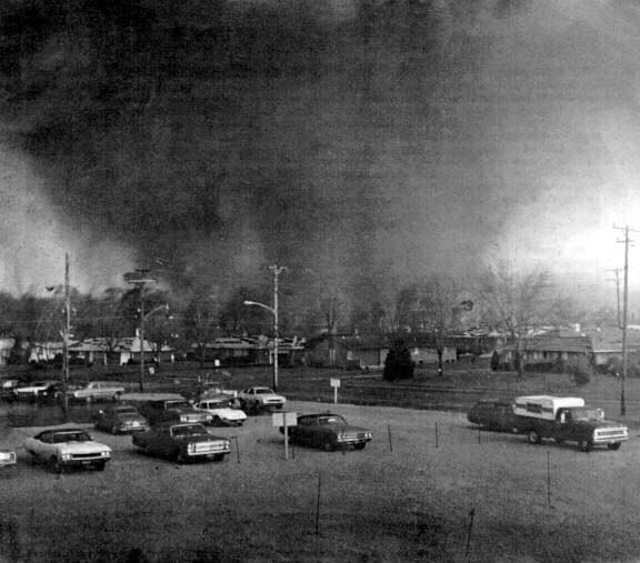
Pulling bodies from the debris
The worst natural disaster ever to occur in the United States in terms of loss of life hit Galveston Island in Texas on September 8, 1900. It was a tropical storm that gained enough strength over the Gulf of Mexico to become a Category 4 hurricane by the time it made landfall in Texas. The city of Galveston, Texas, which lies on the eastern end of Galveston Island, was the hardest hit by this devastating storm and it was hit hard indeed.

On September 3rd and 4th of 1900, a tropical storm first approached and then moved over the island nation of Cuba. By September 6th, the storm was moving northwest of Key West, Florida. The storm then moved out over the Gulf of Mexico in a northeasterly direction, and it was assumed that it would continue this way. However, as the storm gained strength, it took a westerly path. This new direction put Galveston, which had a population of 37,000 at the time, directly in the way of the storm.

It was unclear to meteorologists whether the storm would hit Galveston. The weather on the island was not entirely congruent with what would be expected if a hurricane were approaching. Nevertheless, meteorologist Isaac M. Cline, the man in charge of the Galveston Weather Station at the time, felt that a warning should be issued in spite of the lack of telltale signs, and he ordered it. He noticed some ominous weather conditions, such as a particularly high tide on the evening of the 7th. He chose to keep an eye on such things and report them to the mainland as they occurred.

By the early morning of September 8th, the tidewater reached the lower portions of Galveston. There were also abnormally high and frequent swells. It began to rain lightly around 9:00 a.m. and was raining heavily by 12:00 p.m. It was windy the entire day, but winds didn’t reach hurricane speeds in Galveston until around 5:00 p.m. The winds were last recorded at the weather station at about 6:00 p.m. at around 100 miles an hour. It is estimated that they reached speeds of 130-140 mph before the storm passed.

That evening a huge storm surge bombarded the city and flooded the streets. All the residents could do was try to get to higher ground before they were swept away or battered with debris. Unfortunately, the highest point in the city at the time was only roughly 8-7 feet above sea level. The storm surge reached a height of 15.7 feet. A lot of people lost their lives in the struggle to get above the seawater that had invaded their city.

The aftermath of the Great Storm of 1900 was horrifying by all accounts. Debris and dead bodies were strewn about as survivors picked their way through the streets. They themselves were battered and bruised and likely trying to find missing loved ones. Estimates for lives lost range from 6,000 to 12,000, but the general consensus is that between 6,000 and 8,000 people died that day. More than 3,500 homes were destroyed and there was around 20 million dollars worth of damage done. That would be roughly 700 million dollars today.

There were so many dead bodies that plans had to be hatched for their disposal immediately. One such plan involved removing the dead by barge and dumping them into the gulf. This was done and to the horror of those working to dispose of them, many of the bodies were brought back to the island on currents. This left residents with no other option than to burn or bury the bodies right where they lie.

It must have been hard for the residents of Galveston in the aftermath of the storm, but something needed to be done so that another similar tragedy could be avoided in the future. The people banded together and not only rebuilt their city, but raised it and its infrastructure up to eight feet in some places. On top of that, a sea wall was built to protect the city from storm surges, but it only protects parts of the city, leaving the rest of the island vulnerable. The wall still stands today.

Sources

Cline, Isaac M., Special Reports of the Galveston Hurricane of September 8, 1900, retrieved 10/28/09, history.noaa.gov/stories_tales/cline2.html

The Great Galveston Hurricane of 1900, retrieved 10/28/09, celebrating200years.noaa.gov/magazine/galv_hurricane/welcome.html#intro

Hurricane History, Galveston 1900, retrieved 10/28/09, nhc.noaa.gov/HAW2/english/history.shtml#galveston

Wednesday, September 20, 2017

1974's Super Tornado Outbreak

The Xenia Tornado
The 1974 Tornado Outbreak, or the Super Tornado Outbreak, was a widespread outbreak of tornadoes in the United States and Canada. According to the National Oceanic and Atmospheric Administration (NOAA), it was the worst outbreak of tornadoes in United States history. The damage, number of tornadoes and the length of all the tornadoes paths of destruction combined give it this distinction. Surprisingly, the 1925 Tri-State Tornado was more than twice as deadly, though nowhere near as widespread.

The forecast on April 2, 1974 called for severe thunderstorms–a problem, but not indicative of what was to come. On April 3, the outbreak began. The worst of it took place between 2 and 10 pm, but the storms continued until April 4. One hundred forty-eight tornadoes occurred in 13 states and Canada during this short period.

South Carolina, North Carolina, Virginia, West Virginia, Tennessee, New York, Illinois, Ohio, Alabama, Georgia, Mississippi, Michigan and Kentucky were affected.  Six of the tornadoes were a five on the Fujita scale. More than 20 were rated four and more than 30 were rated three. Ohio, Indiana, Kentucky and Alabama were hit with the F5s.

The 1974 Tornado Outbreak carved more than 2,500 miles of destruction. One hundred eighteen tornadoes had destruction paths that measured a mile or more. Three hundred thirty people died and more than 5,000 were injured.

The year before the outbreak was also a very active year for tornadoes. There were roughly 1,100 in all. Nonetheless, no outbreak took place that year that can compare to 1974 and none have since. Though, judging by the April tornadoes of 2011, it is not out of the question. It is quite possible that a similar or worse outbreak will occur in the United States, which is the country most susceptible to tornadoes on Earth.

Wednesday, February 1, 2017

Interesting Facts About Tornadoes

F5 in Manitoba by
Justin1569
Tornadoes are dangerous, violent and unpredictable storms. Even the weakest of them can harm people and cause property damage. Scientists measure them on the Fujita Scale. Those in the middle of the Fujita Scale–F3s–are as strong as or even stronger than Category 5 hurricanes in terms of wind speed. They have been portrayed in fiction as magical cyclones that can whisk you away to far off lands and as interesting funnels that harmlessly move things about. The reality is far more frightening, though no less interesting.

Tornadoes are Most Common in the United States

While not constricted to the United States, tornadoes most often occur in the spring and fall months in the U.S. An average of 800 to 1,000 reported tornadoes occur in the United States annually. They cause an average of 70 to 80 deaths in the country and more than 1,000 injuries–much more some years. Property damage from tornadoes can be in the billions in a single year.

Tornadoes Can Move and Spin Very Fast


Tornadoes are columns of air that appear during thunderstorms, however small. The columns spin or rotate at varying speeds from 400 miles per hour to more than 300 miles per hour. Tornadoes can travel at speeds up to 70 miles per hour, making them very difficult to outrun, even in a vehicle. They are also quite unpredictable, which lends to the danger they present.

The Paths of Tornadoes Can be Terrifyingly Wide and Long

The width of a tornado can be as much as a mile and wipe out whole neighborhoods as it goes along. Once it touches down, a tornado can cut a path 50 miles long before dissipating. Tornadoes like these are the exception rather than the rule, but it is best to stay out of the way of any tornado.

Not All Tornadoes Form Noticeable Funnels


It is a mistake to be on the lookout for noticeable funnels during thunderstorms, despite them being a tornado's most noteworthy characteristic. Tornadoes are, by nature, invisible. Only when a tornado sucks in moisture, dirt or debris does it become visible. Even then, rain or dark clouds may hinder a person's view of the tornado.

Tornadoes Can Last More than the Usual Few Minutes and They Can Happen at Any Time

Tornadoes are more common in spring and summer, as mentioned above. However, they can happen at any time of year. Furthermore, they are more common in the afternoon, but that does not mean they cannot happen at night or in the morning. Once they get started, they can last anywhere from a brief moment to an hour.

It is Impossible to Give Significant Warning for a Tornado

Unlike other weather events, it is not possible to give more than a few minutes of warning for a tornado. Tornadoes are much like tsunamis in that the situation must be read properly in order for people to predict the outcome. Weather experts can put out tornado watches hours in advance when they see a storm that may produce tornadoes. However, they cannot give a tornado advisory more than an average 13 minutes in advance at this time. That is why it is essential to listen carefully to the weather when there is a tornado watch.

When it comes to tornadoes, preparing for the unexpected is the only safeguard. Even homes that are built to withstand tornadoes can be leveled in a strong one. It is important to know where to take shelter in the event of a tornado and to pay attention when there are thunderstorms, especially if you are east of the Rockies in the United States.

Sources

Tornadoes, retrieved 6/5/11, environment.nationalgeographic.com/environment/natural-disasters/tornado-profile

Tuesday, January 3, 2017

Brennender Berg-Germany's "Burning Mountain"

Guide sign at Brennender Berg
Brennender Berg, or Burning Mountain, is a coal fire that tourists can visit in Saarland, Germany. Just park up at the Dudweiler Cemetery and walk about 15 minutes into the woods to find a rocky gorge where you can experience some of the effects of this centuries-old coal fire.

Brennender Berg ignited in 1688. No one is quite sure how. There are stories that a shepherd lit a tree on fire and that ignited the coal. It's also possible that the fire started on its own–a common enough occurrence. Whatever the case, it burned dramatically for a long time. Tourists through the centuries would come up to see burning red rocks and smoke emitting from crevices. They also noted the smell of sulfur.

Today, Brennender Berg has quieted down. You can still seek the rocky gorge, under which it burns, and feel the warmth of the rocks, but smoke is rare and the smell has subsided. There is an information sign at the site, but it's in German. Do your research before you go.

Wednesday, December 21, 2016

The Everlasting Lightning Storm on the Catatumbo River

Over the mouth of the Catatumbo River in Zulia, Venezuela, where it pours into Lake Maracaibo, one of the most spectacular natural weather phenomena occurs nightly for roughly one-third of the year. This phenomenon is a barrage of lightning storms that crackle across the sky. It is known locally as Ralampago del Catatumbo. The lightning is accompanied by storm clouds and rain. There is a rumor that the lightning is silent. However, those who have gotten close to it can attest that it sounds like any other lightning storm. It is just visible from so far off, it is possible to see it and not hear it.

The Catatumbo Lightning typically begins at night or in the evening. The lightning tends to strike in the clouds. However, like all lightning, it is unpredictable. It can flash at average rates of up to five times per minute and can continue for up to ten hours. Even happening once a year, this lightning would be quite a show. The lightning is so bright that sailors can see it for miles, thus it is nicknamed "the Lighthouse of Maracaibo."

As far as history can tell us, the Catatumbo Lightning is not a new phenomenon. The first known mention of it was in 1597, though it could have been happening for much longer. The story goes that when Sir Francis Drake attempted to launch a surprise attack in the area, he was unsuccessful because the Catatumbo Lightning lit up the night sky, revealing his invading force to the locals.

There are several hypotheses to explain the Catatumbo Lightning. They include uranium in local bedrock; trapped wind, heat and moisture and the way the aforementioned things circulate in the area; methane and oil deposits are even culprits. Some speculate that it could be any combination of these things as well. In reality, we simply do not know. We do know that the lake is on the edge of the Atlantic, there are flat swamps in the area and the mountains do a good job of trapping the elements near the opening of the Catatumbo River. The trapping of moisture and heat seems to make sense, given that the Catatumbo Lightning slows down or stops during droughts. This shows us that, at the very least, moisture plays some role in creating these massive storms.

Seeing the Catatumbo Lightning is an adventure for outsiders. There is no resort at the edge of the lake from which you can view the lightning while sipping a cocktail. We are talking about the kind of place where you need mosquito netting, a poncho and probably a boat. You may find yourself in a village where toilets do not flush into pipes or where houses are on stilts. This is only for the truly adventurous. If that does not sound appealing, there are plenty of videos of the Ralampago del Catatumbo.

Sources

The Catatumbo Everlasting Lightning Storm, retrieved 7/27/11, stormchaser.ca/lightning/catatumbo/Catatumbo.html

Tuesday, November 22, 2016

The 7 Tallest Volcanoes On Earth

Mount Saint Helens 1985
At this time, there are more than 1,500 volcanoes on the surface of the Earth. This number does not include the volcanoes that exist under the ocean, of which there are potentially thousands. The largest of these 1,500 volcanoes pose a major threat to those who live in their shadows. Some of them even have the ability to threaten lives thousands of miles away. Here is a list of some of the largest volcanoes on Earth by height. Some of them are not a major threat, despite their size. Others have killed thousands in the past and could readily do so again in the future.

Mount Vesuvius


Height: Roughly 4,000 feet

Type: Stratovolcano

Status: Active

Year of Last Eruption: 1944

Mount Vesuvius is located on the west coast of Italy, on the Tyrrhenian Sea. This is the very same volcano that was responsible for the destruction of the cities of Pompeii and Herculaneum in 79 A.D. Mount Vesuvius is the shortest of the volcanoes on this list. However, the height of this volcano has little bearing on how deadly it can be. Today there are millions of people living within range of this volcano. A particularly large eruption could have terrible consequences.

Mount Pelee


Height: Roughly 4,582 feet

Type: Compound Volcano

Status: Dormant

Year of Last Eruption: 1929-1932

Mount Pelee is located on the island of Martinique in the West Indies. This volcano became famous after an eruption in 1902 that destroyed the town of St. Pierre. An estimated 29,000 people were killed.

Mount Pinatubo


Height: Roughly 4,872 feet

Type: Stratovolcano

Status: Active

Year of Last Eruption: A secondary eruption occurred in 1994.

Mount Pinatubo is located in the Philippines. The largest eruption that has happened there in recent history occurred in 1991. This eruption was unique in that scientists had been able to predict it and many people had been evacuated. Nonetheless, 847 people died and 23 went missing as a result of the massive eruption.

Mount St. Helens


Height: 8 Roughly 8,364 feet

Type: Stratovolcano

Status: Active

Year of Last Eruption: 2004-2008

Mount St. Helens is located in the Cascade Mountains in Washington State. It is the most famous volcano in the U.S.A. because of its eruption in 1980. The eruption caused the north face of this once picturesque mountain to collapse. It destroyed nearly 1,314 miles of forest and killed hundreds of large animals. Fifty-seven people were killed in all, despite warnings of an imminent eruption.

Mount Tambora


Height: Roughly 9,354 feet

Type: Stratovolcano

Status: Active

Year of Last Eruption: 1967

Mount Tambora is located on the island of Sumbawa in Indonesia. Mount Tambora had the largest eruption in recorded history in 1816. That year became known as the year without summer all over the world. The eruption killed an estimated 80,000 people. The people of New England, nearly 10,000 miles away, were hit pretty hard by weather changes caused by the eruption. They recorded frost every month of that year and it even snowed in June.

Mount Etna


Height: Roughly 10,925 feet

Type: Stratovolcano

Status: Active

Year of Last Eruption: 2008

Mount Etna is located on the island of Sicily, Italy. It is the most active and tallest of all the volcanoes in Europe. Mount Etna has erupted more than 200 times since 1500 BC. This includes a series of eruptions that lasted thirteen years between 1972 and 1992. Eruptions from the volcano have threatened to destroy the town of Catania several times. Attempts have been made twice to divert the flow of lava away from the town. Both efforts failed.

Mauna Loa


Height: Roughly 13,000 feet above sea level, Roughly 56,000 feet from base to summit

Type: Shield Volcano

Status: Active

Year of Last Eruption: 1984

Mauna Loa is located on the island of Hawaii. Its name means Long Mountain in the language of the natives. It is not only the tallest volcano on Earth, but it is also the tallest mountain from base to summit. The volcano takes up roughly half of the island. Mauna Loa has erupted 33 times since 1843.

These volcanoes are some of the largest in terms of elevation. There are other, larger volcanoes on Earth that are considered larger due to volume and potential for disaster. For example, the megavolcano that resides under Yellowstone Park has the potential to affect weather the world over and to kill millions. The volcanoes listed here are big and dangerous, but they are not the only volcanoes on the planet that are a threat to mankind.

Sources


Ball, Jessica, Mount Etna-Italy, retrieved 7/15/09, geology.com/volcanoes/etna/

Mauna Loa; Earth’s Largest Volcano, retrieved 7/15/09, hvo.wr.usgs.gov/maunaloa

Ball, Jessica, Mount Vesuvius-Italy, retrieved 7/15/09, geology.com/volcanoes/vesuvius

Tambora, retrieved 7/15/09, earlham.edu/~ethribe/web/tambora.htm

Pinatubo Volcano “The Sleeping Giant Awakens”, retrieved 7/15/09, park.org/philippines/pinatubo

Discover Mount-Pelee, one of the deadliest volcano ever, retrieved 7/15/09, mount-pelee.com/index.php/component/option,com_frontpage/itemid,1l/lang;en/

Friday, October 28, 2016

The Events Leading Up To The 1902 Eruption of Mount Pelee


Photo of the eruption
Mt. Pelee is a stratovolcano located on the island of Martinique in the Caribbean. In 1902, the volcano erupted and virtually destroyed the growing city of St. Pierre. It was the deadliest eruption of the 20th century. An interesting thing about this eruption is the number of events that occurred leading up to it and the apparent complacency of the people that lived in St. Pierre.

In January of 1902, Mt. Pelee began to develop new fumaroles and there was increased fumarole activity on the mountain. Apparently, this had happened in the past and the volcano had not erupted in living memory, so it was not seen as a problem. Other ominous signs came from the mountain, over time, such as the spitting of ash and rumbling coming from the mountain. Still, the people of St. Pierre ignored the mountain. Some residents even continued taking excursions up the mountain.

The volcano started showing what would now be considered sure signs of a pending eruption on April 23, 1902. Small explosions began occurring near the top of the mountain. These explosions caused wildlife to flee. Countless fire ants and centipedes descended upon the local sugar mill. They bit people and animals alike and caused a great deal of turmoil. The most terrifying thing was the procession of thousands of venomous snakes that slithered through the St. Pierre. An estimated 50 people and 200 animals died as a result of bites from these panicked snakes.

The once dry Etang Sec crater of Mt. Pelee began to fill with scalding water. Visitors to the mountain said that they heard the sound of a bubbling cauldron coming from inside the crater. On May 5, the rim of the crater crumbled and the heated water poured into the Blanche River. A lahar formed when the water from the Etang Sec joined with pyroclastic debris. The lahar moved at an estimated rate of 62 miles an hour. When it reached the ocean, it caused a large wave to flood portions of the St. Pierre waterfront. Between 23 and 150 people were killed that day.

When people became nervous and decided to try and leave St. Pierre, the government wouldn’t let them. Barriers were set up on a road leading out of the city and residents were forced to return. They were told that St. Pierre was the safest place to be during the heightened activity from Mt. Pelee. This misinformation was also published in newspapers. The result was a stream of people actually entering St. Pierre in the time before the eminent eruption. By the time Mt. Pelee erupted, on May 8, 1902, the estimated population of St. Pierre was 28,000 or more.

The events that occurred before the 1902 eruption of Mt. Pelee would have led to the evacuation of all people near the volcano today. However, in 1902, volcanology was a relatively new science and many people mistakenly thought that the volcano was harmless. It was anything but. It erupted so forcefully that every person in St. Pierre, except two very lucky men, died as a result of the blast, the hot gas cloud or the pyroclastic flows.