Friday, October 28, 2016

The Events Leading Up To The 1902 Eruption of Mount Pelee


Photo of the eruption
Mt. Pelee is a stratovolcano located on the island of Martinique in the Caribbean. In 1902, the volcano erupted and virtually destroyed the growing city of St. Pierre. It was the deadliest eruption of the 20th century. An interesting thing about this eruption is the number of events that occurred leading up to it and the apparent complacency of the people that lived in St. Pierre.

In January of 1902, Mt. Pelee began to develop new fumaroles and there was increased fumarole activity on the mountain. Apparently, this had happened in the past and the volcano had not erupted in living memory, so it was not seen as a problem. Other ominous signs came from the mountain, over time, such as the spitting of ash and rumbling coming from the mountain. Still, the people of St. Pierre ignored the mountain. Some residents even continued taking excursions up the mountain.

The volcano started showing what would now be considered sure signs of a pending eruption on April 23, 1902. Small explosions began occurring near the top of the mountain. These explosions caused wildlife to flee. Countless fire ants and centipedes descended upon the local sugar mill. They bit people and animals alike and caused a great deal of turmoil. The most terrifying thing was the procession of thousands of venomous snakes that slithered through the St. Pierre. An estimated 50 people and 200 animals died as a result of bites from these panicked snakes.

The once dry Etang Sec crater of Mt. Pelee began to fill with scalding water. Visitors to the mountain said that they heard the sound of a bubbling cauldron coming from inside the crater. On May 5, the rim of the crater crumbled and the heated water poured into the Blanche River. A lahar formed when the water from the Etang Sec joined with pyroclastic debris. The lahar moved at an estimated rate of 62 miles an hour. When it reached the ocean, it caused a large wave to flood portions of the St. Pierre waterfront. Between 23 and 150 people were killed that day.

When people became nervous and decided to try and leave St. Pierre, the government wouldn’t let them. Barriers were set up on a road leading out of the city and residents were forced to return. They were told that St. Pierre was the safest place to be during the heightened activity from Mt. Pelee. This misinformation was also published in newspapers. The result was a stream of people actually entering St. Pierre in the time before the eminent eruption. By the time Mt. Pelee erupted, on May 8, 1902, the estimated population of St. Pierre was 28,000 or more.

The events that occurred before the 1902 eruption of Mt. Pelee would have led to the evacuation of all people near the volcano today. However, in 1902, volcanology was a relatively new science and many people mistakenly thought that the volcano was harmless. It was anything but. It erupted so forcefully that every person in St. Pierre, except two very lucky men, died as a result of the blast, the hot gas cloud or the pyroclastic flows.

Wednesday, October 12, 2016

The Devastation of the Okeechobee Hurricane


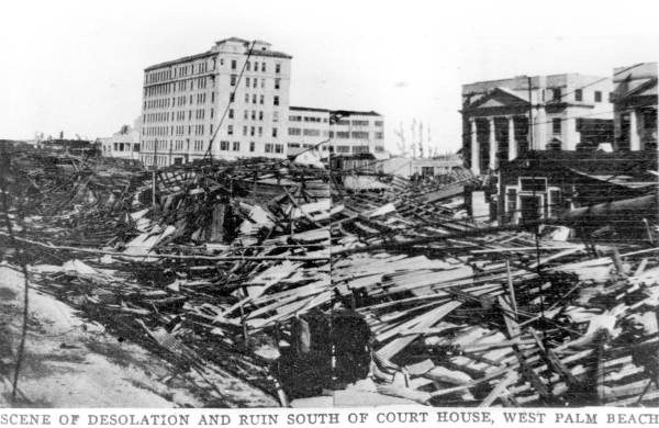
The aftermath in West Palm Beach
The Okeechobee Hurricane or, in Puerto Rico, Hurricane San Felipe Segundo, occurred in September of 1928. The hurricane made landfall in the Leeward Islands, Guadeloupe, Puerto Rico, the Bahamas and the state of Florida. The Okeechobee Hurricane was at different times a category three, four and five hurricane as it made its destructive path through these locations. The damage caused by this hurricane was at the time estimated to be one hundred million dollars. By today’s standards that would be equal to one billion dollars. A total of 4,078 people or more perished as a direct result of the storm.

The Okeechobee Hurricane was first spotted 900 miles east of Guadeloupe on September 10, 1928. Two days later, on September 12, the hurricane struck the island chain as a category three. The storm caused around 1,200 deaths in Guadeloupe and major property damage. The hurricane then hit the Leeward Islands causing 45 deaths. The damage to crops and property was devastating.

The very next day, the hurricane was at a category five when it made landfall in Puerto Rico. Winds were reported around 160 miles an hour on the island. Around 36 hours before the storm hit, the residents were warned of the danger. They were able to prepare, so loss of life was comparably low with only 300 fatalities. Hurricane Okeechobee was responsible for 50 million dollars (500 million dollars today) worth of damage in Puerto Rico. Several hundred thousand people on the island lost their homes.

The hurricane then moved across the Bahamas as a category four. In the Bahamas, residents were also prepared. There was not a single fatality on the island. Though, 18 people went missing when their sailboat was lost at sea. They are presumed dead.

On September 16, Hurricane Okeechobee made landfall in the state of Florida as a category four. The results were devastating. The eye of the storm passed over Palm Beach County and went straight for Lake Okeechobee. Most of the damage sustained on the Florida coast was in the area of Palm Beach, but loss of life in the area was minimal. There were only 26 fatalities. The population near Lake Okeechobee would not be nearly as lucky.

When the hurricane finally hit Lake Okeechobee winds were around 140 miles per hour. As the winds blew southward across the lake, a storm surge overflowed a dike on its southern edge. This resulted in floods covering hundreds of square miles of farming land and communities. A smaller flood on the northern part of the lake occurred a little later, when the dikes there crumbled.

Many of the bodies of the deceased were lost as floodwaters poured into the Everglades. The floodwaters remained for some weeks, so it was very difficult for relief workers to recover and bury the dead. Eventually mass graves were dug for the bodies, but after a few days even that was not enough. The bodies began to decay in the Florida sun, so survivors were forced to burn the dead.

All told, 2,500 people or more were killed in Florida that fateful day. Around 1,100 of them were buried in one grave in the Port Mayaca Cemetery. The hurricane caused 25 million dollars(250 million dollars today) worth of property damage in Florida.

After leaving Lake Okeechobee, the hurricane moved northeast over Florida and into Georgia and the Carolinas causing only minimal damage in these places. In the aftermath of the hurricane, it became apparent to authorities that flood control on Lake Okeechobee needed to be brought up to par. Building codes were also changed in the hopes that future hurricanes would not cause such extensive damage.

Sources

Doup, Liz, 1928-Okeechobee, Sun-Sentinel, September 11, 1988

Wikipedia, Okeechobee Hurricane, retrieved 6/5/06, wikipedia.org/wiki/Okeechobee_Hurricane

Sunday, October 2, 2016

The 1925 Tri-State Tornado


Aftermath in Griffin, Indiana
The 1925 Tri-State Tornado was the single most deadly tornado in United States history. This massive cyclone ripped through parts of southeastern Missouri, southern Illinois and southwestern Indiana. Today, most experts believe that the Tri-State Tornado was a five on the Fujita Scale, with winds between 261 and 318 miles per hour. It traveled a total of 219 miles, giving it the longest recorded tornado track in the entire world.

The Tri-State Tornado started off in the Ozark Mountains near Ellington, Missouri at 1:01 p.m. on March 18, 1925. At the time, weather forecasters were not allowed to mention tornados in their warnings, and really forecasting a tornado was impossible. Even in recent years, tornados are unpredictable. However, today we are at least allowed to hear speculations of a forming tornado and decide if we want to take shelter. In 1925, this wasn’t an option. So, as the tornado was forming in the Ozarks and getting ready to race across three states at average speeds of between 56 and 73 miles per hour, people were complacently going about their day.

Fourteen minutes after the Tri-State Tornado formed, it was in Annapolis, Missouri. It destroyed 90% of the town and killed several citizens. It then moved across the farmlands of southeastern Missouri and across the Mississippi River. It did the most damage in Illinois. It hit town after town, destroying homes, businesses and vehicles, uprooting trees and killing citizens. The tornado killed 243 people in Murphysboro alone. It is estimated that the tornado averaged 3/4 of a mile wide, but was up to a mile wide at times.

After wreaking havoc in Illinois, the Tri-State Tornado moved into Indiana. It broke up twelve minutes after destroying a quarter of the town of Princeton, Indiana. In its wake were utterly devastated towns. Schools were destroyed with children still inside them. Houses filled with their occupants were moved across the land. Rescue workers dug through rubble to search for survivors for days in some places. There were fires, power outages and shattered families.

The Tri-State Tornado claimed an astounding 695 lives. More than two thousand people were injured by the storm and roughly fifteen thousand homes were destroyed. Since the time of the Tri-State Tornado, the ban on using the word tornado in weather forecasting has been lifted. Awareness of these dangerous storms has increased exponentially. Therefore, people are able to prepare for them. Nonetheless, it is very difficult and, at times, impossible to predict a tornado. Another tornado of this magnitude in the area could still be disastrous.

Monday, September 26, 2016

The Alnwick Poison Gardens

Alnwick Gardens
Photo by xlibber

The Alnwick Gardens are a group of public gardens attached to Alnwick Castle in Northumberland. The castle itself is the second largest in Great Britain. One of the gardens that helps make up the Alnwick Gardens is the Alnwick Poison Garden. This garden boasts some of the world's most dangerous plants, hence the name.

The history of the Alnwick Gardens goes back to 1750. The modern gardens were designed after a long period of neglect. The current Duchess of Northumberland decided to revamp the gardens when she became mistress of Alnwick Castle. The project began around 2000, but she did not begin the Poison Garden until five years later. The Duchess wanted a garden that was filled with narcotic, poisonous and deadly plants. The initial design included some medicinal plants, but she had them removed to maintain the concept of the Poison Garden.

The Duchess of Northumberland had father and son garden designers Jacques and Peter Wirtz design the modern Alnwick Gardens. Besides the Poison Garden, there is the Rose Garden, the Tree House, the Serpent Garden, the Ornamental Garden, the Bamboo Labyrinth and more. The Poison Garden has arguably the most socially significant purpose of all the Alnwick Gardens. Guests who visit the Alnwick Poison Garden are led by guides who teach them about the plants and about drug abuse prevention. The drug abuse prevention message stems from the plants that reside in the Poison Garden.

The plants that grow in the Alnwick Poison Garden could be used to make an array of illegal narcotics. There are poppies, which are used to make opium. There is Atropa belladonna, also known as deadly nightshade, which is famous for its use as a poison. Belladonna is also a hallucinogenic. Cocoa also grows in the Poison Garden. Cocoa sounds like a lovely plant, but it is actually used to make cocaine. Strychnos nux-vomica is another deadly plant, which is used to make strychnine. Also included are hemlock, cannabis and more.

The Poison Garden at Alnwick Gardens is on around the clock surveillance for the safety of the public and would-be thieves. Some of the plants are even kept in specially fenced areas to avoid accidental poisoning or theft of the plants for use in making narcotics. The message at the Poison Garden is anti-drug, so it is of the utmost importance that the plants there be used to educate the public, not harm people.

Source

Alnwick Garden, retrieved 12/2/10

Monday, September 12, 2016

See a Night Sky Underground at New Zealand's Glowworm Caves


Intricate sign at the caves
Photo by A.Aruninta

The Glowworm Caves, or the Waitomo Caves, are amazing natural wonders located in Waitomo on North Island in New Zealand. There is a series of them with millions of glowing larvae, pupae and bugs populating their ceilings. Visitors liken the effect of these glowing creatures to that of a particularly starry night sky. In some spots, you can see glowing dots on strands that hang from above, almost like icicle Christmas lights.

The little bugs, larvae and pupae that are responsible for the decor of the Glowworm Caves are known Arachnocampa luminosa, New Zealand fungus gnats or, less commonly, glowing spider bugs. These bugs go through four basic life stages. They begin as eggs, which hatch to become larvae (during which time they molt four times), which in turn pupate. Then comes the adult. New Zealand fungus gnats begin glowing when they reach the larval stage of their development.

Arachnocampa luminosa larvae spend their days hiding in cracks and crevices in the Glowworm Caves. At night, they come out and hide in little silk tunnels they have constructed. These silk tunnels are for catching prey. They are also used as a dwelling of sorts during the pupal stage of their development. New Zealand fungus gnats spend about three weeks as eggs, six to twelve months as larvae and about twelve days as pupae. Adults come out of the pupal stage unable to eat. They have no mouths. They will only survive long enough to procreate. For the male Arachnocampa luminosa, this will be between three and five days. The female will only survive one or two days. After laying her eggs, she will sometimes stop glowing, always dying shortly thereafter.

There is no shortage of New Zealand fungus gnats in New Zealand. However, the Glowworm Caves are the most popular places to view these bioluminescent bugs. The darkness of the caves makes them a perfect place to witness the glow of the Arachnocampa luminosa.

There are literally hundreds of guided tours available for visitors to the Glowworm Caves. The caves may be entered on foot or via the Waitomo River in a raft or canoe.

Sources

New Zealand Fungus Gnat (NZ Glowworm), retrieved 9/12/16

Sunday, August 28, 2016

The Great Pacific Garbage Patch


The amount of waste in the world’s oceans has been surging in the past century, and the problem continues to get worse. It is at the point where there are areas of the ocean where trash outnumbers sea life (including plankton). These areas of the ocean are known as trash swills. There are a number of them on Earth, and each of Earth’s oceans contains at least one. The greatest of all of these trash swills is commonly known as the ‘Great Pacific Garbage Patch.’ It is also known as the ‘Plastic Continent.’

The ‘Great Pacific Garbage Patch’ is located in the Pacific Ocean between Hawaii and California. It is roughly 1,000 miles off of the coast of California. Trash from Japan, the United States, Mexico and various other countries are caught in the ocean’s currents and eventually wind up in the North Pacific Subtropical Convergence Zone. Some of this trash breaks into pieces, eventually comes free and floats away, sinks to the ocean floor or floats on or below the surface.

It is difficult to determine the size of this mass of plastic and trash for various reasons. Firstly, the ‘Great Pacific Garbage Patch’ does not stay still. The collection of plastic and trash is also amorphous, so getting a precise measurement would take some doing. There is also the fact that not all of the trash is on the surface. To get a correct measurement of its size, one would have to measure its depth as well, which is no simple task. Estimates regarding the size of the ‘Great Pacific Garbage Patch’ have ranged from the size of Texas to one and a half times the size of the United States.

Eighty percent of the ‘Great Pacific Garbage Patch’ is recyclable plastic material. It’s no wonder some people have taken to calling it the ‘Plastic Continent.’ There is also no feasible way of removing it and recycling it. The ‘Great Pacific Garbage Patch’ is getting larger with no end in sight. And this is only the tip of the iceberg of the world’s plastic problem. Just imagine how much of it is sitting around on this planet, not being recycled and endangering wildlife. When you take into account the fact that plastic has only been mass-produced for the past sixty years or so, it is easy to imagine that our oceans may be literally clogged with plastic in the foreseeable future.

The amount of plastic compared to the amount of sea life in the ‘Great Pacific Garbage Patch’ is 6:1. Researchers have been discovering all kinds of sea life, including marine birds, with pieces of plastic from the swill in their stomachs. Some accounts have made it seem as if researchers would be hard pressed to find an animal in that area without some plastic in its stomach. The plastic breaks down into smaller pieces and begins to look like food to the animals. They can also become entangled in or otherwise inhibited by the debris. This can be a major problem if it stops the animal from being able to move or eat.

At this time, attempts are being made to study the ‘Great Pacific Garbage Patch.’ However, nothing is being done about it and there may be nothing that can be done about it. No country is going to claim responsibility for the waste and end up footing a bill that could probably reach the billions. There is also the question of how all of that floating trash could possibly be collected and where would we put it? It has been estimated that the ‘Great Pacific Garbage Patch’ contains roughly 3.5 million tons of trash.

Update: Research into the impact of the Great Pacific Garbage Patch and how to clean it up is currently ongoing. There is no doubt that the task will be monumental.

Sources

Randille, Michelle, Great Pacific Garbage Patch, retrieved 12/16/09, discovery.com/news/2009/08/28/pacific-garbage.html

Think Beyond Plastic, Garbage Patch, retrieved 12/16/09, greatgarbagepatch.org/index.html

De-mystifying the “Great Pacific Garbage Patch” or “Trash Vortex,” retrieved 12/16/09, marinedebris.noaa.gov/info/patch.html#3

Saturday, July 16, 2016

Yellowstone's Morning Glory Pool

The pool has barely retained its blue color.
Photo by Miguel Hermoso Cuesta

Yellowstone National Park is home to some of the most amazing natural sights in the world, not least of which is the Morning Glory Pool. The Morning Glory Pool is a hot spring that attracts quite a few visitors. It is known for its vibrant color.  However, much of that has diminished over the past decades. Nonetheless, the pool is still stunning to behold. The change in the pool’s color is also very interesting in that it gives us a first hand look at the effect that pollution can have on the world that surrounds us.

The Morning Glory Pool is located on the northern edge of the Upper Geyser Basin. It was named in 1883 for its magnificently deep blue color that nearly matched the flower for which it was named.

This pool is roughly 23 feet by 26 feet and is about 23 feet deep. Currently, the temperature of the water in the Morning Glory Pool is around 171.6 degrees Fahrenheit. The water is clear enough that you can see the way that the sides taper down into its depths. Viewed from some angles, this gives the illusion that the pool is in fact running down into the center. This also makes the pool seem as if it has a “stem,” which makes its name that much more appropriate.

Unfortunately, the pool has changed color over the years because of the acts of uncaring or unwitting visitors. Tons (yes, tons) of trash have been thrown into the pool, effectively blocking the vents that keep the pool so hot. Thermophilic bacteria that need high temperatures to survive cause the blue color of the pool.

When the vents became blocked by trash, the temperature in the pool started to drop, thus killing some of these bacteria. The drop in temperature also made it possible for other bacteria to thrive in the Morning Glory Pool. These new bacteria are red, yellow and orange and are changing the pool’s color from the outside in. As the pool gets cooler, the new bacteria move closer to its center. Given enough time, the entire pool could change if the vents do not get opened back up.

An old road used to go directly by the Morning Glory Pool, so there were many more visitors to it in the past. Today that road is gone. Visitors must walk or bicycle for 1.5 miles both ways to get to the pool; a three-mile trip total. This means fewer visitors and fewer opportunities to steal pieces of the edge of the pool or throw trash into its depths.

Because the Morning Glory Pool is a geyser it is hoped that it will one day blow the trash loose and thus remove the blockage from its thermal vents. However, whether it will do so or not is uncertain, especially with the amount of trash that is in it. For now, we can only hope that some effort on our part or some natural occurrence will return the pool to its original, magnificent state.