Showing posts with label Places. Show all posts

Monday, September 26, 2016

The Alnwick Poison Gardens

Alnwick Gardens
Photo by xlibber

The Alnwick Gardens are a group of public gardens attached to Alnwick Castle in Northumberland. The castle itself is the second largest in Great Britain. One of the gardens that helps make up the Alnwick Gardens is the Alnwick Poison Garden. This garden boasts some of the world's most dangerous plants, hence the name.

The history of the Alnwick Gardens goes back to 1750. The modern gardens were designed after a long period of neglect. The current Duchess of Northumberland decided to revamp the gardens when she became mistress of Alnwick Castle. The project began around 2000, but she did not begin the Poison Garden until five years later. The Duchess wanted a garden that was filled with narcotic, poisonous and deadly plants. The initial design included some medicinal plants, but she had them removed to maintain the concept of the Poison Garden.

The Duchess of Northumberland had father and son garden designers Jacques and Peter Wirtz design the modern Alnwick Gardens. Besides the Poison Garden, there is the Rose Garden, the Tree House, the Serpent Garden, the Ornamental Garden, the Bamboo Labyrinth and more. The Poison Garden has arguably the most socially significant purpose of all the Alnwick Gardens. Guests who visit the Alnwick Poison Garden are led by guides who teach them about the plants and about drug abuse prevention. The drug abuse prevention message stems from the plants that reside in the Poison Garden.

The plants that grow in the Alnwick Poison Garden could be used to make an array of illegal narcotics. There are poppies, which are used to make opium. There is Atropa belladonna, also known as deadly nightshade, which is famous for its use as a poison. Belladonna is also a hallucinogenic. Cocoa also grows in the Poison Garden. Cocoa sounds like a lovely plant, but it is actually used to make cocaine. Strychnos nux-vomica is another deadly plant, which is used to make strychnine. Also included are hemlock, cannabis and more.

The Poison Garden at Alnwick Gardens is on around the clock surveillance for the safety of the public and would-be thieves. Some of the plants are even kept in specially fenced areas to avoid accidental poisoning or theft of the plants for use in making narcotics. The message at the Poison Garden is anti-drug, so it is of the utmost importance that the plants there be used to educate the public, not harm people.

Source

Alnwick Garden, retrieved 12/2/10

Monday, September 12, 2016

See a Night Sky Underground at New Zealand's Glowworm Caves


Intricate sign at the caves
Photo by A.Aruninta

The Glowworm Caves, or the Waitomo Caves, are amazing natural wonders located in Waitomo on North Island in New Zealand. There is a series of them with millions of glowing larvae, pupae and bugs populating their ceilings. Visitors liken the effect of these glowing creatures to that of a particularly starry night sky. In some spots, you can see glowing dots on strands that hang from above, almost like icicle Christmas lights.

The little bugs, larvae and pupae that are responsible for the decor of the Glowworm Caves are known Arachnocampa luminosa, New Zealand fungus gnats or, less commonly, glowing spider bugs. These bugs go through four basic life stages. They begin as eggs, which hatch to become larvae (during which time they molt four times), which in turn pupate. Then comes the adult. New Zealand fungus gnats begin glowing when they reach the larval stage of their development.

Arachnocampa luminosa larvae spend their days hiding in cracks and crevices in the Glowworm Caves. At night, they come out and hide in little silk tunnels they have constructed. These silk tunnels are for catching prey. They are also used as a dwelling of sorts during the pupal stage of their development. New Zealand fungus gnats spend about three weeks as eggs, six to twelve months as larvae and about twelve days as pupae. Adults come out of the pupal stage unable to eat. They have no mouths. They will only survive long enough to procreate. For the male Arachnocampa luminosa, this will be between three and five days. The female will only survive one or two days. After laying her eggs, she will sometimes stop glowing, always dying shortly thereafter.

There is no shortage of New Zealand fungus gnats in New Zealand. However, the Glowworm Caves are the most popular places to view these bioluminescent bugs. The darkness of the caves makes them a perfect place to witness the glow of the Arachnocampa luminosa.

There are literally hundreds of guided tours available for visitors to the Glowworm Caves. The caves may be entered on foot or via the Waitomo River in a raft or canoe.

Sources

New Zealand Fungus Gnat (NZ Glowworm), retrieved 9/12/16

Saturday, July 16, 2016

Yellowstone's Morning Glory Pool

The pool has barely retained its blue color.
Photo by Miguel Hermoso Cuesta

Yellowstone National Park is home to some of the most amazing natural sights in the world, not least of which is the Morning Glory Pool. The Morning Glory Pool is a hot spring that attracts quite a few visitors. It is known for its vibrant color.  However, much of that has diminished over the past decades. Nonetheless, the pool is still stunning to behold. The change in the pool’s color is also very interesting in that it gives us a first hand look at the effect that pollution can have on the world that surrounds us.

The Morning Glory Pool is located on the northern edge of the Upper Geyser Basin. It was named in 1883 for its magnificently deep blue color that nearly matched the flower for which it was named.

This pool is roughly 23 feet by 26 feet and is about 23 feet deep. Currently, the temperature of the water in the Morning Glory Pool is around 171.6 degrees Fahrenheit. The water is clear enough that you can see the way that the sides taper down into its depths. Viewed from some angles, this gives the illusion that the pool is in fact running down into the center. This also makes the pool seem as if it has a “stem,” which makes its name that much more appropriate.

Unfortunately, the pool has changed color over the years because of the acts of uncaring or unwitting visitors. Tons (yes, tons) of trash have been thrown into the pool, effectively blocking the vents that keep the pool so hot. Thermophilic bacteria that need high temperatures to survive cause the blue color of the pool.

When the vents became blocked by trash, the temperature in the pool started to drop, thus killing some of these bacteria. The drop in temperature also made it possible for other bacteria to thrive in the Morning Glory Pool. These new bacteria are red, yellow and orange and are changing the pool’s color from the outside in. As the pool gets cooler, the new bacteria move closer to its center. Given enough time, the entire pool could change if the vents do not get opened back up.

An old road used to go directly by the Morning Glory Pool, so there were many more visitors to it in the past. Today that road is gone. Visitors must walk or bicycle for 1.5 miles both ways to get to the pool; a three-mile trip total. This means fewer visitors and fewer opportunities to steal pieces of the edge of the pool or throw trash into its depths.

Because the Morning Glory Pool is a geyser it is hoped that it will one day blow the trash loose and thus remove the blockage from its thermal vents. However, whether it will do so or not is uncertain, especially with the amount of trash that is in it. For now, we can only hope that some effort on our part or some natural occurrence will return the pool to its original, magnificent state.

Monday, June 27, 2016

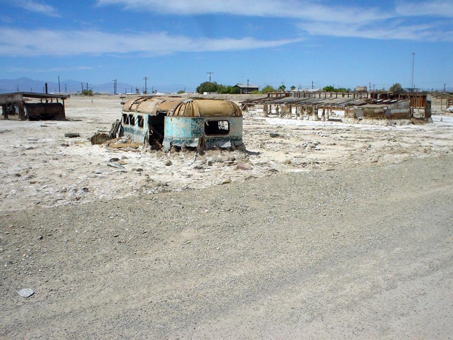
Salton Sea: A Former Paradise Abandoned

Abandoned buildings at Salton Sea
The Salton Sea is a semi-man-made lake in California, which sits directly on the San Andreas fault. It is home to numerous bird and fish species, some of which are endangered. Because it is an important stop along the Pacific Flyway, it is critical that it is safe for the birds that flock there.

Unfortunately, there have been several major die-offs for both the birds and the fish of the Salton Sea. And there is much controversy surrounding the cause of these die-offs.

The Salton Sea lies in a natural basin called the Salton Basin or the Salton Trough. This basin is very close to the Colorado River and it is easy for water in the area to drain into the basin because it is so far below sea level. The Salton Basin has been filled with water off and on as far back as 700 A.D. It was most recently filled in 1905.

In 1905 an irrigation canal headworks on the Colorado River broke and the river began pouring into the Salton Basin. Unfortunately, the town of Salton and some Native American land were submerged by the in-flowing water. Luckily, the area was not highly developed and all escaped what could have been a major disaster. Engineers were unable to fix the break immediately and so the Colorado River continued to pour into the Salton Basin for more than a year. Thus, the Salton Sea, as we know it today, was born. It is currently around 45 miles long and 20 miles wide.

The area of the Salton Sea has natural salt deposits and the Colorado River is relatively salty itself. Therefore, when the river poured into the basin and dissolved some of the natural salt, the Salton Basin became a salt lake. In fact, it is currently 25% saltier than ocean water because some of the water that flows in today is also salty. Because it is roughly 227 feet below sea level, no water flows out of the Salton Sea, only in. The lake is able to maintain its water level because of evaporation, but the salt doesn’t evaporate. So, what we are left with is a lake that constantly collects more and more salt, but does not dispose of it.

The Salton Sea is fed by the New River, the White River, the Alamo River and numerous agricultural drain offs and creeks. Therefore, not only water comes into the Salton Sea; fish do as well. There are many species of fish in the Salton Sea and it has become a very popular fishing spot for both humans and birds. In little more than one hundred years, the Salton Sea has developed an ecosystem that is critical to the survival of several endangered species. The problem is that it may not be a safe place for these animals.

A number of large-scale die-offs of fish and birds have occurred on the Salton Sea over the years. Some people believe that contaminants are coming into the Salton Sea from the drain offs and rivers and that they are causing the die-offs. Others believe that it is the excess of naturally occurring salt, nutrients and Selenium. One thing is agreed upon by both groups–something is killing these animals and something has to be done about it. Various organizations are looking into the problem and researching possible solutions.

The Salton Sea is a wonderful part of the California landscape and it is rather unique. It would be a horrible thing to lose all of the animals that grace the lake and only be left with what would essentially be a giant bowl of salt water and animal bones. Fortunately, we live in a time where it may be possible to stop the Salton Sea from “dying,” though we haven’t been able to stop things such as this before. However, with some elbow grease and awareness, a biological travesty can be avoided. Thankfully, we have that choice.


Monday, April 25, 2016

How Gas Build-Up at Lake Nyos Killed More Than 1,000 People


One of the CO2 vents at Lake Nyos
Lake Nyos is a crater lake in northwestern Cameroon. It is one of only three lakes in the world known to be capable of causing a very unique sort of natural disaster. Lake Monoun, which is 60 miles to the southeast of Nyos and Lake Kivi on the Congo/Rwanda border are the other two, but neither of them has been as deadly as Lake Nyos. On August 26, 1986, 1,700 people in the vicinity of the lake died mysteriously. Animals in the area were also found dead. There were no signs of trauma or disease. It appeared as if these people just fell down where they stood and died. Some were even still asleep in their beds.

After the disaster, scientists turned to Lake Nyos for answers. It was noticed that the normally deep blue lake had turned a reddish brown color. This color lead scientists to suspect that the iron at the bottom of the lake had somehow made its way to the top, where it oxidized and temporarily changed that lake’s color. When the lake was studied, abnormal amounts of carbon dioxide were found at the bottom of the lake. This would lead them to the answer that they were looking for.

Two years before the Lake Nyos Disaster, a similar event had occurred at Lake Monoun. Thirty-seven people had lost their lives when they suffocated on CO2 that suddenly escaped from the lake. Apparently the same thing had happened at Nyos, but on a much larger scale.

There is an extremely large amount of carbon dioxide at the bottom of Lake Nyos because the lake does not naturally “turn over” frequently, the way most lakes do. The carbon dioxide enters the lake naturally and because the lake is very deep, the upper waters of the lake hold down the carbon dioxide. The waters are also unusually calm, and the lack of movement keeps the carbon dioxide at the bottom of the lake as well. When something does naturally occur to cause some of the lake’s water to turn over, the result is a massive release of the built up gas.

On the day of the Lake Nyos disaster, something occurred (scientists aren’t sure exactly what, but several good theories exist) that made the CO2 rise rapidly out of the lake, causing the lake to bubble tremendously and spray water into the air. Because CO2 is heavier than air, it didn’t disperse. It sank down into the valleys surrounding the lake in a cloud that is estimated to have been roughly 328 ft. tall. The cloud moved through the area at speeds between 12.42 and 31.06 miles per hour. The average running speed for a human is roughly 12 miles per hour. It is unlikely that anyone would have been able to outrun it, even if they had noticed that something invisible and deadly was moving toward them.

The cloud killed nearly every human and animal within a 15-mile radius of the lake. Because the carbon dioxide was in concentrations higher than 10%, it caused everything in the area that breathes to become asphyxiated. There were very few survivors. Some people that were high enough above the lake survived, others simply woke up two days later, after the cloud had dispersed. Some people, who were lucky enough to be inside their homes with the doors and windows closed, survived as well.

The carbon dioxide in Lake Nyos began building up again immediately after the disaster. It was soon realized that another disaster would be inevitable if nothing was done to prevent it. So, scientists developed a pump with a long pipe going to the bottom of the lake, which brings the gas to the surface. The pipe then empties out above the water line with a harmless spray of water and gas. At this time, there are not enough pumps on the lake to prevent another disaster. However, efforts are being made to install more pumps and ensure that nothing like the tragedy that occurred on August 26, 1986, will ever happen again.

Sources

The Lake Nyos Disaster, retrieved 11/24/09, geo.arizona.edu/geo5xx/geos577/projects/kayzer/html/lake_nyos_disaster.html

Fink, Micah, Volcanic Killers, Degassing Lake Nyos, retrieved 11/24/09, pbs.org/wnet/savageplanet/o/volcano/01/indexmid.html

Lake Nyos (1986), retrieved 11//24/09, geology.sdsu.edu/how_volcanoes_work/Nyos.html

Wednesday, March 23, 2016

The Moeraki Boulders of Koekohe Beach


Moeraki Boulders
The Moeraki Boulders
Moeraki Boulders are just one of the many naturally occurring oddities that are found on Koekohe Beach and surrounding areas in New Zealand. Some have likened the appearance of these boulders to the bowling balls of giants, who have long since abandoned their game. In a way, they do look like bowling balls because some of them are nearly perfectly spherical. This sort of boulder occurs naturally elsewhere, but the number of them in the area and the beauty of the surrounding New Zealand landscape seems to draw people to the Moeraki Boulders in particular.

Roughly 56 million years ago (during the Paleocene Epoch), small bits of wood, fossils and bones on the bottom of the ancient sea floor began to accumulate layers in what is now New Zealand. Over time, these small formations grew larger and larger in much the same way an oyster's pearl grows in size. The large, round stones that resulted from this process are known as septarian concretions. They eventually became trapped in the stunning sheer cliffs that grace the coast of Kohekohe Beach between Moeraki and Hampden, New Zealand.

When erosion began to take its toll on the cliffs, the ancient Moeraki Boulders were freed. Today, they are scattered across the landscape like errant marbles. Some are not spherical, but are oval instead. These Moeraki Boulders look like dinosaur eggs–really big ones, at that. Some of them have cracked open and revealed their softer, eroded interior. Some of these are big enough for a man to sit in, giving the appearance that he has just been hatched from the ancient stone. The biggest of the Moeraki Boulders is close to nine feet in diameter and weighs several tons.

The surfaces of the Moeraki Boulders are cracked, causing them to look like turtle shells. The reason for this cracking is yet unknown to science. We do know that the interiors of the boulders are weaker than the exteriors, yet the exteriors are cracked. Some of the boulders are much smaller than others. The cracked surface makes them look like large turtles half-buried in the sand.

An 1848 drawing by W.B.D. Mantell shows the Koekohe Beach with more of the Moeraki Boulders than are currently there, so we know they are slowly vanishing. However, more are still trapped in the cliffs, as evidenced by those that are only half-exposed today. There is no telling how many of them are still waiting to be revealed.

Sources

De Hek, Danny, retrieved 10/28/10, newzealandnz.co.nz/destinations/moeraki.html

Facts about Moeraki Boulders, retrieved 10/28/10, moeraki-boulders-facts.php

Evans, RJ, The Mysterious Moeraki Boulders, kuiositas.com/2010/09/mysterious-moeraki-boulders.html

Sunday, March 13, 2016

Interesting Facts About Iceland's Volcanoes

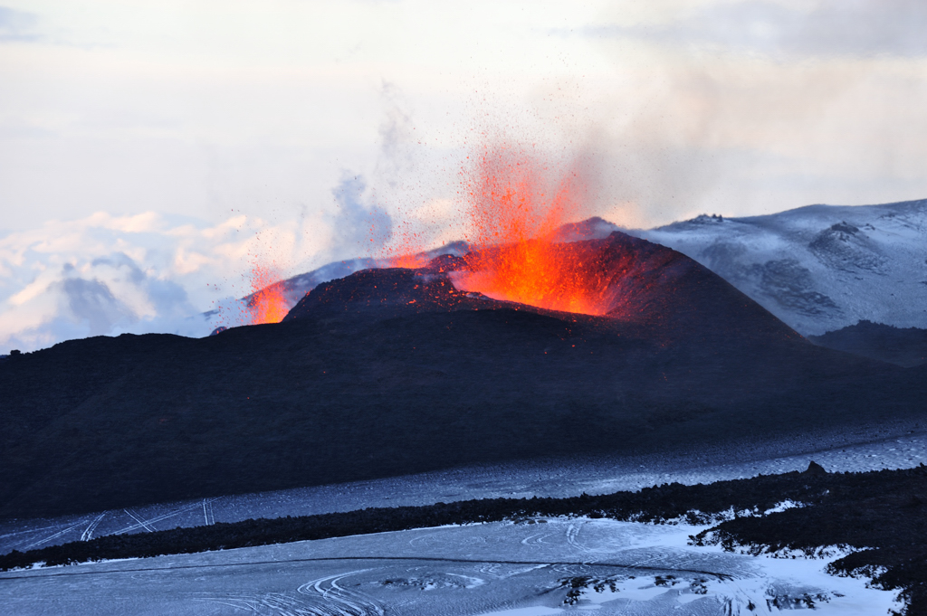
Fire spewing out of Eyjafjallajokull
during the 2010 eruptions
Courtesy of Ulrich Latzenhofer
Iceland and its volcanoes have been in the news a lot in the past few years. The Eyjafjallajokull volcano in Iceland was been very active in March and April of 2010. The ash spewing forth from this volcano resulted in the grounding of flights as far away as England, due to the danger it presents to airplanes. Prior to this tantrum, the Eyjafjallajokull volcano had not erupted for nearly 200 years. All of this attention serves to remind us that Iceland is a land of many volcanoes, some of which can have global consequences should they erupt. With that in mind, here are a few facts about Iceland's volcanoes that can give us an idea of what goes on there in the "land of fire and ice."

Hawaii gets a lot of attention for its volcanoes. This is because it was formed by volcanoes. Evidence of their activity is present everywhere there. Nonetheless, there are only two active volcanoes in the State of Hawaii. Iceland has between 20 and 30 active volcanoes. That is more active volcanoes than any other place on Earth.

The most active volcano in Iceland is Hekla. Hekla has an elevation of 4,892 feet. It is a stratovolcano that is located in southern Iceland. Hekla has erupted roughly once every ten years for the past fifty years. A Hekla eruption can come on with little to no warning and can last for weeks or months. Hekla was less active in the past fifty years. However, for some time, there was hardly a century that passed without at least one eruption from Hekla.

Iceland was formed from volcanic activity, like Hawaii. The American and Eurasian tectonic plate boundary goes through Iceland. The two plates pull apart, making it easy for lava to push through the gap. This is how Iceland was formed and why it has so many active volcanoes today.

In the past 500 years, nearly one-third of the Earth's lava output has spewed forth in Iceland. Furthermore, 83% of the world's sub glacial eruptions have occurred in Iceland. To put that into perspective, the area of Iceland is 39,707 square miles of land. The entire Earth has roughly 57,393,000 square miles of land area. Iceland is sure pumping out a lot of lava for such a small portion of the Earth.

From the above, you can clearly see why Iceland is called the "land of ice and fire." Of course, given its position on this Earth, there is a lot of ice in Iceland. However, residents can warm up by taking a dip in the large number of the geothermal spas there. Despite the scary number of active volcanoes, Iceland is easily one of the most beautiful and interesting places on Earth.

Sources

Volcanology Highlights, retrieved 4/16/10, volcano.si.edu/world/region.cfm?rnum=17&rpage=highlights

Volcanoes in Iceland, retrieved 4/16/10, kwintessential.co.uk/articles/article/Iceland?Volcanoes-in-Iceland/538

Seach, John, Hekla Volcano, retrieved 4/16/10, volcanolive.com.hekla.html


Tuesday, February 23, 2016

Mexico's Cave of Crystals

See the man for scale?
Photo by Alexander Van Driessche
The Cave of Crystals, known as Cueva de los Cristales by locals, is the site of the largest natural crystals known to man. It is located roughly 1,000 feet beneath Naica Mountain in Mexico’s Chihuahuan Desert in Chihuahua, Mexico. The Cave of Crystals is the second of such caves found beneath the mountain. The Cave of Swords was discovered at a depth of about 400 feet and contains similar, but smaller, crystals.

The Naica Mine, in which the Cave of Crystals is located, has been the site of silver mining since 1794. Since that time, gold, zinc, lead and now these crystals have been discovered there. The Cave of Crystals was discovered in April of 2000 by two brothers who worked for the Naica Mine. What they saw inside the cave were gypsum crystals, some of which were roughly 40 feet long, up to four feet in diameter and weighing up to 55 tons. The heat inside of the cave was stifling and workers could not spend a significant amount of time there. Nonetheless, an iron door was fitted to act as an entrance to the cave and deter thieves. It didn’t work. Not long after, a miner found a small crevice and snuck into the cave to try and steal some crystals. He suffocated and baked within the cave. His body was found later.

Juan Manuel Garcia-Ruiz of the University of Grenada conducted a study of the crystals and the cave in an attempt to explain why these gypsum crystals are so gigantic compared to others found on Earth. He found small pockets of liquid within the crystals. By studying the liquid, he came to the conclusion that the gypsum crystals were able to grow so large due to two factors: the cave’s steady temperature of roughly 136 degrees Fahrenheit and the mineral rich water that once filled the Cave of Crystals. Juan refers to the cave as “the Sistine Chapel of crystals.”

The stifling heat and humidity in the cave, which is caused by heat emanating from a magma chamber below the mountain, make it impossible for visitors to stay in the cave for very long. Nonetheless, guided tours are available when the cave is open. Visitors have reported hallucinations and brain malfunctions. Some tourists have even collapsed inside the cave and had to be removed. If you are brave enough to enter the beautiful Cave of Crystals, you will see a site that visitors have likened to Superman’s “Fortress of Solitude.”

Sources

Lovgren, Stefan, April 6, 2007, National Geographic News, Giant Crystal Cave’s Mystery Solved, retrieved 2/25/10, nationalgeographic.com/news/2007/04/070406-giant-crystals.html

Crystal Cave of Giants in Mexico, retrieved 2/25/10, crystalinks.com/mexicocrystals.html


Wednesday, February 3, 2016

Jellyfish Lake: Swim Safely With Swarms of Harmless Jellyfish

Jellyfish Lake
Jellyfish Lake
Photo by Onyo
Jellyfish Lake is one of five unique lakes that can be found on Mecherchar Island in Palau, Micronesia. It is known as Ongeim’l Tketau by the locals. What is so unique about these lakes is that they are the only places on Earth where a person can swim with millions of jellyfish without fear of being killed. Jellyfish Lake is the only one of these lakes that is open to the public for swimming and snorkeling. Therefore, it is the most famous.

Jellyfish Lake is a saltwater lake that was once connected to the Pacific Ocean. The lake is roughly 98.4 feet deep and covers an area of 12 acres. When the separation between the lake and the ocean occurred, some species of sea creatures became trapped in the lake. One of these species was the ancestor of the Mastigius jellyfish that now occupy Jellyfish Lake.

Jellyfish Lake is filled with more than 10,000 jellyfish of the Mastigius species. These jellyfish are also sometimes known as Darwin’s jellyfish. Since these jellyfish have become cut off from the ocean, they have adapted to life with very few predators. Over time, their nemastocysts or “stinging cells” have become smaller and smaller. They have been minimized to the point that these jellyfish are virtually harmless to humans. This is absolutely unheard of anywhere else on Earth.

Visitors to Jellyfish Lake not only get to have the otherworldly experience of swimming with jellyfish, but they get to witness an odd jellyfish migration of sorts. Each day, during the early morning hours, all of the jellyfish move toward the eastern side of the lake. At midmorning they all swim to the western side of the lake. This is done to optimize the amount of sunlight available to their main food source (algae). At night, they all move closer to the floor of the lake, where there is a significant build up of hydrogen sulfide (also beneficial to the algae).

Jellyfish Lake is a one-of-a-kind place and the Palau authorities are determined to keep it that way. Visitors are asked to be very careful not to litter. They are also asked to stick to snorkeling and swimming. SCUBA gear can affect the delicate balance of the lake. It is important that this lake and its counterparts be preserved for future generations.

Sources

Jellyfish Lake, retrieved 2/5/10, pbs.org/edens/palcw/p_sea_b_8.htm

Palau Jellyfish Lake, retrieved 2/5/10, jellyfishfacts.net/palau-jellyfish-lake.html


Thursday, January 28, 2016

Cloud Forests: Endangered Habitat

Bella Vista Cloud Forest Reserve
Photo by JDPEcuador
Cloud forests are some of the most magical looking environments on Earth. Their beauty is the first and most noticeable thing about them. However, beyond the layers of mist and cloud that often blanket the trees of these forests, there is much more to be seen. There is beauty in the life of these forests and the life they provide to the organisms in and around them. Unfortunately, we may not have them to enjoy for much longer.

Cloud forests are mountain forests that exist in tropical and sub-tropical climates. They appear at altitudes between 1,600 and 10,000 feet, with the lower cloud forests appearing on mountainous islands in the ocean. The trees within these forests are 50 feet or more in the lower altitudes. Cloud forests in higher altitudes have shorter trees.

One of the most important and interesting things about cloud forests is the water that they use and produce. The forests actually collect the water from the mists and clouds that hover and move through their trees. This water is then taken into the forest and provided to local life - even humans. The La Tigra cloud forest in Honduras supplies 40 percent of the water that 850,000 nearby humans use. For this reason, cloud forests are sometimes called "nature's water towers."

There is quite an abundance of life in cloud forests. However, an estimated 80 percent of the varieties of life forms in cloud forests have gone undocumented. There simply has not been much study on the flora and fauna of cloud forests. We do know that some endangered species, such as gorillas, make their homes in cloud forests. Other species are found only in cloud forests. That means that if the cloud forests disappear, so will these animals and plants.

Some experts have calculated that it may take as little as a decade for all of the cloud forests to vanish from the Earth. Changes in the amount of water available to the forests through mists can cloud would change the ecosystem. Deforestation -- which is occurring in some cloud forests -- would remove the cloud forests altogether. It is feared that global warming and pollution will transform the lush, misty, water producing landscapes into dry forests and then perhaps worse.

Because of the obvious threats to the world's cloud forests, the Cloud Forest Conservation Alliance was formed. The alliance helps raise awareness of the problem and aid in conserving these fairy tale forests. A lot is going to need to change and quite a bit of research will have to be crammed into a short time. If we only have ten years, we have a lot of work to do if we want to lessen the impact we are having on this planet.

Sources

Cloud Forest Conservation Alliance, retrieved 6/21/11, cloudforests.org


Roach, Joan, Cloud Forests Fading in the Mist, Their Treasures Little Known, retrieved 6/21/11, news.nationalgeographic.com/news/2001/08/0813_cloudforest.html