Monday, April 25, 2016

How Gas Build-Up at Lake Nyos Killed More Than 1,000 People


One of the CO2 vents at Lake Nyos
Lake Nyos is a crater lake in northwestern Cameroon. It is one of only three lakes in the world known to be capable of causing a very unique sort of natural disaster. Lake Monoun, which is 60 miles to the southeast of Nyos and Lake Kivi on the Congo/Rwanda border are the other two, but neither of them has been as deadly as Lake Nyos. On August 26, 1986, 1,700 people in the vicinity of the lake died mysteriously. Animals in the area were also found dead. There were no signs of trauma or disease. It appeared as if these people just fell down where they stood and died. Some were even still asleep in their beds.

After the disaster, scientists turned to Lake Nyos for answers. It was noticed that the normally deep blue lake had turned a reddish brown color. This color lead scientists to suspect that the iron at the bottom of the lake had somehow made its way to the top, where it oxidized and temporarily changed that lake’s color. When the lake was studied, abnormal amounts of carbon dioxide were found at the bottom of the lake. This would lead them to the answer that they were looking for.

Two years before the Lake Nyos Disaster, a similar event had occurred at Lake Monoun. Thirty-seven people had lost their lives when they suffocated on CO2 that suddenly escaped from the lake. Apparently the same thing had happened at Nyos, but on a much larger scale.

There is an extremely large amount of carbon dioxide at the bottom of Lake Nyos because the lake does not naturally “turn over” frequently, the way most lakes do. The carbon dioxide enters the lake naturally and because the lake is very deep, the upper waters of the lake hold down the carbon dioxide. The waters are also unusually calm, and the lack of movement keeps the carbon dioxide at the bottom of the lake as well. When something does naturally occur to cause some of the lake’s water to turn over, the result is a massive release of the built up gas.

On the day of the Lake Nyos disaster, something occurred (scientists aren’t sure exactly what, but several good theories exist) that made the CO2 rise rapidly out of the lake, causing the lake to bubble tremendously and spray water into the air. Because CO2 is heavier than air, it didn’t disperse. It sank down into the valleys surrounding the lake in a cloud that is estimated to have been roughly 328 ft. tall. The cloud moved through the area at speeds between 12.42 and 31.06 miles per hour. The average running speed for a human is roughly 12 miles per hour. It is unlikely that anyone would have been able to outrun it, even if they had noticed that something invisible and deadly was moving toward them.

The cloud killed nearly every human and animal within a 15-mile radius of the lake. Because the carbon dioxide was in concentrations higher than 10%, it caused everything in the area that breathes to become asphyxiated. There were very few survivors. Some people that were high enough above the lake survived, others simply woke up two days later, after the cloud had dispersed. Some people, who were lucky enough to be inside their homes with the doors and windows closed, survived as well.

The carbon dioxide in Lake Nyos began building up again immediately after the disaster. It was soon realized that another disaster would be inevitable if nothing was done to prevent it. So, scientists developed a pump with a long pipe going to the bottom of the lake, which brings the gas to the surface. The pipe then empties out above the water line with a harmless spray of water and gas. At this time, there are not enough pumps on the lake to prevent another disaster. However, efforts are being made to install more pumps and ensure that nothing like the tragedy that occurred on August 26, 1986, will ever happen again.

Sources

The Lake Nyos Disaster, retrieved 11/24/09, geo.arizona.edu/geo5xx/geos577/projects/kayzer/html/lake_nyos_disaster.html

Fink, Micah, Volcanic Killers, Degassing Lake Nyos, retrieved 11/24/09, pbs.org/wnet/savageplanet/o/volcano/01/indexmid.html

Lake Nyos (1986), retrieved 11//24/09, geology.sdsu.edu/how_volcanoes_work/Nyos.html

Wednesday, March 23, 2016

The Moeraki Boulders of Koekohe Beach


Moeraki Boulders
The Moeraki Boulders
Moeraki Boulders are just one of the many naturally occurring oddities that are found on Koekohe Beach and surrounding areas in New Zealand. Some have likened the appearance of these boulders to the bowling balls of giants, who have long since abandoned their game. In a way, they do look like bowling balls because some of them are nearly perfectly spherical. This sort of boulder occurs naturally elsewhere, but the number of them in the area and the beauty of the surrounding New Zealand landscape seems to draw people to the Moeraki Boulders in particular.

Roughly 56 million years ago (during the Paleocene Epoch), small bits of wood, fossils and bones on the bottom of the ancient sea floor began to accumulate layers in what is now New Zealand. Over time, these small formations grew larger and larger in much the same way an oyster's pearl grows in size. The large, round stones that resulted from this process are known as septarian concretions. They eventually became trapped in the stunning sheer cliffs that grace the coast of Kohekohe Beach between Moeraki and Hampden, New Zealand.

When erosion began to take its toll on the cliffs, the ancient Moeraki Boulders were freed. Today, they are scattered across the landscape like errant marbles. Some are not spherical, but are oval instead. These Moeraki Boulders look like dinosaur eggs–really big ones, at that. Some of them have cracked open and revealed their softer, eroded interior. Some of these are big enough for a man to sit in, giving the appearance that he has just been hatched from the ancient stone. The biggest of the Moeraki Boulders is close to nine feet in diameter and weighs several tons.

The surfaces of the Moeraki Boulders are cracked, causing them to look like turtle shells. The reason for this cracking is yet unknown to science. We do know that the interiors of the boulders are weaker than the exteriors, yet the exteriors are cracked. Some of the boulders are much smaller than others. The cracked surface makes them look like large turtles half-buried in the sand.

An 1848 drawing by W.B.D. Mantell shows the Koekohe Beach with more of the Moeraki Boulders than are currently there, so we know they are slowly vanishing. However, more are still trapped in the cliffs, as evidenced by those that are only half-exposed today. There is no telling how many of them are still waiting to be revealed.

Sources

De Hek, Danny, retrieved 10/28/10, newzealandnz.co.nz/destinations/moeraki.html

Facts about Moeraki Boulders, retrieved 10/28/10, moeraki-boulders-facts.php

Evans, RJ, The Mysterious Moeraki Boulders, kuiositas.com/2010/09/mysterious-moeraki-boulders.html

Sunday, March 13, 2016

Interesting Facts About Iceland's Volcanoes

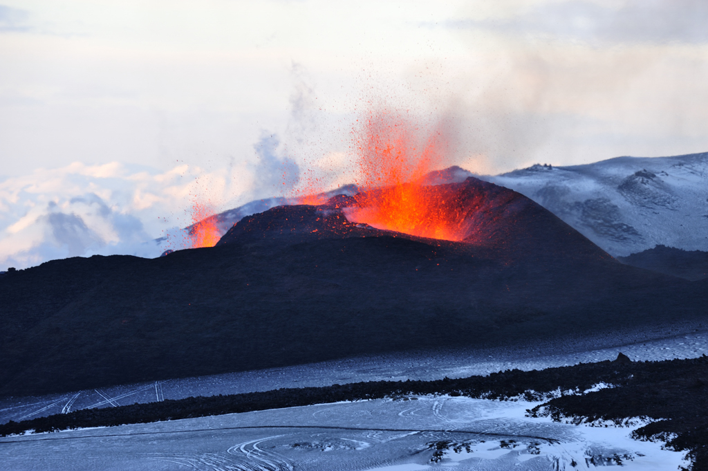
Fire spewing out of Eyjafjallajokull
during the 2010 eruptions
Courtesy of Ulrich Latzenhofer
Iceland and its volcanoes have been in the news a lot in the past few years. The Eyjafjallajokull volcano in Iceland was been very active in March and April of 2010. The ash spewing forth from this volcano resulted in the grounding of flights as far away as England, due to the danger it presents to airplanes. Prior to this tantrum, the Eyjafjallajokull volcano had not erupted for nearly 200 years. All of this attention serves to remind us that Iceland is a land of many volcanoes, some of which can have global consequences should they erupt. With that in mind, here are a few facts about Iceland's volcanoes that can give us an idea of what goes on there in the "land of fire and ice."

Hawaii gets a lot of attention for its volcanoes. This is because it was formed by volcanoes. Evidence of their activity is present everywhere there. Nonetheless, there are only two active volcanoes in the State of Hawaii. Iceland has between 20 and 30 active volcanoes. That is more active volcanoes than any other place on Earth.

The most active volcano in Iceland is Hekla. Hekla has an elevation of 4,892 feet. It is a stratovolcano that is located in southern Iceland. Hekla has erupted roughly once every ten years for the past fifty years. A Hekla eruption can come on with little to no warning and can last for weeks or months. Hekla was less active in the past fifty years. However, for some time, there was hardly a century that passed without at least one eruption from Hekla.

Iceland was formed from volcanic activity, like Hawaii. The American and Eurasian tectonic plate boundary goes through Iceland. The two plates pull apart, making it easy for lava to push through the gap. This is how Iceland was formed and why it has so many active volcanoes today.

In the past 500 years, nearly one-third of the Earth's lava output has spewed forth in Iceland. Furthermore, 83% of the world's sub glacial eruptions have occurred in Iceland. To put that into perspective, the area of Iceland is 39,707 square miles of land. The entire Earth has roughly 57,393,000 square miles of land area. Iceland is sure pumping out a lot of lava for such a small portion of the Earth.

From the above, you can clearly see why Iceland is called the "land of ice and fire." Of course, given its position on this Earth, there is a lot of ice in Iceland. However, residents can warm up by taking a dip in the large number of the geothermal spas there. Despite the scary number of active volcanoes, Iceland is easily one of the most beautiful and interesting places on Earth.

Sources

Volcanology Highlights, retrieved 4/16/10, volcano.si.edu/world/region.cfm?rnum=17&rpage=highlights

Volcanoes in Iceland, retrieved 4/16/10, kwintessential.co.uk/articles/article/Iceland?Volcanoes-in-Iceland/538

Seach, John, Hekla Volcano, retrieved 4/16/10, volcanolive.com.hekla.html


Tuesday, February 23, 2016

Mexico's Cave of Crystals

See the man for scale?
Photo by Alexander Van Driessche
The Cave of Crystals, known as Cueva de los Cristales by locals, is the site of the largest natural crystals known to man. It is located roughly 1,000 feet beneath Naica Mountain in Mexico’s Chihuahuan Desert in Chihuahua, Mexico. The Cave of Crystals is the second of such caves found beneath the mountain. The Cave of Swords was discovered at a depth of about 400 feet and contains similar, but smaller, crystals.

The Naica Mine, in which the Cave of Crystals is located, has been the site of silver mining since 1794. Since that time, gold, zinc, lead and now these crystals have been discovered there. The Cave of Crystals was discovered in April of 2000 by two brothers who worked for the Naica Mine. What they saw inside the cave were gypsum crystals, some of which were roughly 40 feet long, up to four feet in diameter and weighing up to 55 tons. The heat inside of the cave was stifling and workers could not spend a significant amount of time there. Nonetheless, an iron door was fitted to act as an entrance to the cave and deter thieves. It didn’t work. Not long after, a miner found a small crevice and snuck into the cave to try and steal some crystals. He suffocated and baked within the cave. His body was found later.

Juan Manuel Garcia-Ruiz of the University of Grenada conducted a study of the crystals and the cave in an attempt to explain why these gypsum crystals are so gigantic compared to others found on Earth. He found small pockets of liquid within the crystals. By studying the liquid, he came to the conclusion that the gypsum crystals were able to grow so large due to two factors: the cave’s steady temperature of roughly 136 degrees Fahrenheit and the mineral rich water that once filled the Cave of Crystals. Juan refers to the cave as “the Sistine Chapel of crystals.”

The stifling heat and humidity in the cave, which is caused by heat emanating from a magma chamber below the mountain, make it impossible for visitors to stay in the cave for very long. Nonetheless, guided tours are available when the cave is open. Visitors have reported hallucinations and brain malfunctions. Some tourists have even collapsed inside the cave and had to be removed. If you are brave enough to enter the beautiful Cave of Crystals, you will see a site that visitors have likened to Superman’s “Fortress of Solitude.”

Sources

Lovgren, Stefan, April 6, 2007, National Geographic News, Giant Crystal Cave’s Mystery Solved, retrieved 2/25/10, nationalgeographic.com/news/2007/04/070406-giant-crystals.html

Crystal Cave of Giants in Mexico, retrieved 2/25/10, crystalinks.com/mexicocrystals.html


Thursday, February 18, 2016

The Atlantic Garbage Patch: A Trash Vortex in the Ocean

Trash Litter on a Beach in Malaysia
The Great Pacific Garbage Patch is a relatively familiar problem for some people. They have heard of the huge trash swill that pollutes the northern Pacific Ocean. The trash swill that is so large that it is sometimes referred to as a "continent of garbage." This disgusting swirling mass of plastic and other waste has received some attention in the past few years. Now, a second, similar oceanic garbage patch is gaining some attention. That is the Atlantic Garbage Patch.

The Atlantic Garbage Patch is located in the northern Atlantic Ocean. We know that it is large–much larger than it should be. However, it is hard to determine just how big it is. Like its Pacific counterpart, it is amorphous, making it hard to measure. It is also hard to measure just how much plastic is there. It is much denser in some areas than in others. There is no telling which garbage patch is the larger of the two, at this point.

Millions, if not billions, of tiny pieces of plastic make up the bulk of the Atlantic Garbage Patch. These pieces are so small that they are easily mistaken for krill and plankton by larger fish. In fact, in the Pacific Garbage Patch, the plastic bits outnumber the plankton that feed the larger fish. It is unclear if the plastic is that dense in the Atlantic Garbage Patch. The densest area yet discovered in the Atlantic Garbage Patch by students with the Sea Education Association is 520,000 pieces per square mile. That is roughly half the density of the densest measured area of the Pacific Garbage Patch.

Plastic tends to float in seawater. The plastic in the Atlantic Garbage Patch is no exception. It bobs on or near the surface. It is a floating mass of plastic, as opposed to a solid mass. Ships can sail right through it and animals can swim through it, which probably is not a good thing. In the Atlantic Garbage Patch, most of the trash is small pieces of plastic that have been broken down. In the Pacific, plastic such as visibly whole plastic bags and plastic 6-pack rings can be seen floating beneath the surface. This poses many risks to wildlife.

It is interesting to note that researchers have concluded that the Atlantic Garbage Patch has not grown in the past 22 years. This may seem like a good thing, but it is not. Plastic use has increased exponentially in the past several years. It follows that much more plastic would be finding its way into the Atlantic Garbage Patch. If the researchers are right then the plastic is either sinking or breaking down into such small pieces that it could never be recovered, if the effort was ever made.

Source


Lovett, Richard A., Huge Garbage Patch Found in Atlantic Too, retrieved 9/4/10, news.nationalgeographic.com/news/2010/03/100302-new-ocean-trash-garbage-patch

Friday, February 5, 2016

Mud Volcanoes

Chabahar Mud Volcano
Photo by Amirhossein Nikroo
Mud volcanoes are a less terrifying, but still dangerous cousin of magma volcanoes. They are also known as sedimentary volcanoes and gas-oil volcanoes. These volcanoes occur where there are deep deposits of gas and oil beneath the surface. There seems to be a connection with fault lines as well. Like magma volcanoes, mud volcanoes have dormant and active phases. During their active phases, they do not spew liquid hot rock and ash while causing massive earthquakes and lightning storms, but they are capable of spewing fire and enough mud at such a rate to displace or even kill human beings.

If you want to see a mud volcano, Azerbaijan in Eurasia is the place to go. There are no active magma volcanoes in the area, but there are hundreds of mud volcanoes. In fact, Azerbaijan has most of the mud volcanoes on the planet–more than half. However, most of the mud volcanoes there only emit small amounts of cool mud and gases. They can be between 16 feet and 1,640 feet tall. People do not live close enough to them to be affected by active mud volcanoes in Azerbaijan, but that is not the case in other parts of the world.

In 2006, a mud volcano became a problem in a residential area of Sidoarjo, Indonesia. The volcano appeared, erupted and the resulting mudflow killed thirteen people. Thousands have been forced from their homes by what has become known as the Lusi Mud Flow. The mudflow continues to this day. Interestingly, this extraordinarily large and dangerous mud volcano may not be a natural occurrence. Researchers have reason to believe that a local gas exploration well caused the volcano. Somehow, the pressure created led to a vent opening up and pouring excessive amounts of mud into the area.

There is still a lot to learn about mud volcanoes. They have not been studies as extensively as their noisy and deadly cousins have. We do know that built up pressure beneath the surface is involved in the birth of mud vents. We also know that they do not cause as much damage as magma volcanoes, though they can produce earthquakes and balls of fire. Because it appears they can be triggered by careless drilling, there will doubtless be much more research into what exactly causes them and how we humans can avoid being one of these causes.

Sources


Mud Volcanoes in Azerbaijan, retrieved 12/29/10, azerb.com/azmud_volcanoes.htm

Wednesday, February 3, 2016

Jellyfish Lake: Swim Safely With Swarms of Harmless Jellyfish

Jellyfish Lake
Jellyfish Lake
Photo by Onyo
Jellyfish Lake is one of five unique lakes that can be found on Mecherchar Island in Palau, Micronesia. It is known as Ongeim’l Tketau by the locals. What is so unique about these lakes is that they are the only places on Earth where a person can swim with millions of jellyfish without fear of being killed. Jellyfish Lake is the only one of these lakes that is open to the public for swimming and snorkeling. Therefore, it is the most famous.

Jellyfish Lake is a saltwater lake that was once connected to the Pacific Ocean. The lake is roughly 98.4 feet deep and covers an area of 12 acres. When the separation between the lake and the ocean occurred, some species of sea creatures became trapped in the lake. One of these species was the ancestor of the Mastigius jellyfish that now occupy Jellyfish Lake.

Jellyfish Lake is filled with more than 10,000 jellyfish of the Mastigius species. These jellyfish are also sometimes known as Darwin’s jellyfish. Since these jellyfish have become cut off from the ocean, they have adapted to life with very few predators. Over time, their nemastocysts or “stinging cells” have become smaller and smaller. They have been minimized to the point that these jellyfish are virtually harmless to humans. This is absolutely unheard of anywhere else on Earth.

Visitors to Jellyfish Lake not only get to have the otherworldly experience of swimming with jellyfish, but they get to witness an odd jellyfish migration of sorts. Each day, during the early morning hours, all of the jellyfish move toward the eastern side of the lake. At midmorning they all swim to the western side of the lake. This is done to optimize the amount of sunlight available to their main food source (algae). At night, they all move closer to the floor of the lake, where there is a significant build up of hydrogen sulfide (also beneficial to the algae).

Jellyfish Lake is a one-of-a-kind place and the Palau authorities are determined to keep it that way. Visitors are asked to be very careful not to litter. They are also asked to stick to snorkeling and swimming. SCUBA gear can affect the delicate balance of the lake. It is important that this lake and its counterparts be preserved for future generations.

Sources

Jellyfish Lake, retrieved 2/5/10, pbs.org/edens/palcw/p_sea_b_8.htm

Palau Jellyfish Lake, retrieved 2/5/10, jellyfishfacts.net/palau-jellyfish-lake.html