Wednesday, December 21, 2016

The Everlasting Lightning Storm on the Catatumbo River

Over the mouth of the Catatumbo River in Zulia, Venezuela, where it pours into Lake Maracaibo, one of the most spectacular natural weather phenomena occurs nightly for roughly one-third of the year. This phenomenon is a barrage of lightning storms that crackle across the sky. It is known locally as Ralampago del Catatumbo. The lightning is accompanied by storm clouds and rain. There is a rumor that the lightning is silent. However, those who have gotten close to it can attest that it sounds like any other lightning storm. It is just visible from so far off, it is possible to see it and not hear it.

The Catatumbo Lightning typically begins at night or in the evening. The lightning tends to strike in the clouds. However, like all lightning, it is unpredictable. It can flash at average rates of up to five times per minute and can continue for up to ten hours. Even happening once a year, this lightning would be quite a show. The lightning is so bright that sailors can see it for miles, thus it is nicknamed "the Lighthouse of Maracaibo."

As far as history can tell us, the Catatumbo Lightning is not a new phenomenon. The first known mention of it was in 1597, though it could have been happening for much longer. The story goes that when Sir Francis Drake attempted to launch a surprise attack in the area, he was unsuccessful because the Catatumbo Lightning lit up the night sky, revealing his invading force to the locals.

There are several hypotheses to explain the Catatumbo Lightning. They include uranium in local bedrock; trapped wind, heat and moisture and the way the aforementioned things circulate in the area; methane and oil deposits are even culprits. Some speculate that it could be any combination of these things as well. In reality, we simply do not know. We do know that the lake is on the edge of the Atlantic, there are flat swamps in the area and the mountains do a good job of trapping the elements near the opening of the Catatumbo River. The trapping of moisture and heat seems to make sense, given that the Catatumbo Lightning slows down or stops during droughts. This shows us that, at the very least, moisture plays some role in creating these massive storms.

Seeing the Catatumbo Lightning is an adventure for outsiders. There is no resort at the edge of the lake from which you can view the lightning while sipping a cocktail. We are talking about the kind of place where you need mosquito netting, a poncho and probably a boat. You may find yourself in a village where toilets do not flush into pipes or where houses are on stilts. This is only for the truly adventurous. If that does not sound appealing, there are plenty of videos of the Ralampago del Catatumbo.

Sources

The Catatumbo Everlasting Lightning Storm, retrieved 7/27/11, stormchaser.ca/lightning/catatumbo/Catatumbo.html

Tuesday, November 22, 2016

The 7 Tallest Volcanoes On Earth

Mount Saint Helens 1985
At this time, there are more than 1,500 volcanoes on the surface of the Earth. This number does not include the volcanoes that exist under the ocean, of which there are potentially thousands. The largest of these 1,500 volcanoes pose a major threat to those who live in their shadows. Some of them even have the ability to threaten lives thousands of miles away. Here is a list of some of the largest volcanoes on Earth by height. Some of them are not a major threat, despite their size. Others have killed thousands in the past and could readily do so again in the future.

Mount Vesuvius


Height: Roughly 4,000 feet

Type: Stratovolcano

Status: Active

Year of Last Eruption: 1944

Mount Vesuvius is located on the west coast of Italy, on the Tyrrhenian Sea. This is the very same volcano that was responsible for the destruction of the cities of Pompeii and Herculaneum in 79 A.D. Mount Vesuvius is the shortest of the volcanoes on this list. However, the height of this volcano has little bearing on how deadly it can be. Today there are millions of people living within range of this volcano. A particularly large eruption could have terrible consequences.

Mount Pelee


Height: Roughly 4,582 feet

Type: Compound Volcano

Status: Dormant

Year of Last Eruption: 1929-1932

Mount Pelee is located on the island of Martinique in the West Indies. This volcano became famous after an eruption in 1902 that destroyed the town of St. Pierre. An estimated 29,000 people were killed.

Mount Pinatubo


Height: Roughly 4,872 feet

Type: Stratovolcano

Status: Active

Year of Last Eruption: A secondary eruption occurred in 1994.

Mount Pinatubo is located in the Philippines. The largest eruption that has happened there in recent history occurred in 1991. This eruption was unique in that scientists had been able to predict it and many people had been evacuated. Nonetheless, 847 people died and 23 went missing as a result of the massive eruption.

Mount St. Helens


Height: 8 Roughly 8,364 feet

Type: Stratovolcano

Status: Active

Year of Last Eruption: 2004-2008

Mount St. Helens is located in the Cascade Mountains in Washington State. It is the most famous volcano in the U.S.A. because of its eruption in 1980. The eruption caused the north face of this once picturesque mountain to collapse. It destroyed nearly 1,314 miles of forest and killed hundreds of large animals. Fifty-seven people were killed in all, despite warnings of an imminent eruption.

Mount Tambora


Height: Roughly 9,354 feet

Type: Stratovolcano

Status: Active

Year of Last Eruption: 1967

Mount Tambora is located on the island of Sumbawa in Indonesia. Mount Tambora had the largest eruption in recorded history in 1816. That year became known as the year without summer all over the world. The eruption killed an estimated 80,000 people. The people of New England, nearly 10,000 miles away, were hit pretty hard by weather changes caused by the eruption. They recorded frost every month of that year and it even snowed in June.

Mount Etna


Height: Roughly 10,925 feet

Type: Stratovolcano

Status: Active

Year of Last Eruption: 2008

Mount Etna is located on the island of Sicily, Italy. It is the most active and tallest of all the volcanoes in Europe. Mount Etna has erupted more than 200 times since 1500 BC. This includes a series of eruptions that lasted thirteen years between 1972 and 1992. Eruptions from the volcano have threatened to destroy the town of Catania several times. Attempts have been made twice to divert the flow of lava away from the town. Both efforts failed.

Mauna Loa


Height: Roughly 13,000 feet above sea level, Roughly 56,000 feet from base to summit

Type: Shield Volcano

Status: Active

Year of Last Eruption: 1984

Mauna Loa is located on the island of Hawaii. Its name means Long Mountain in the language of the natives. It is not only the tallest volcano on Earth, but it is also the tallest mountain from base to summit. The volcano takes up roughly half of the island. Mauna Loa has erupted 33 times since 1843.

These volcanoes are some of the largest in terms of elevation. There are other, larger volcanoes on Earth that are considered larger due to volume and potential for disaster. For example, the megavolcano that resides under Yellowstone Park has the potential to affect weather the world over and to kill millions. The volcanoes listed here are big and dangerous, but they are not the only volcanoes on the planet that are a threat to mankind.

Sources


Ball, Jessica, Mount Etna-Italy, retrieved 7/15/09, geology.com/volcanoes/etna/

Mauna Loa; Earth’s Largest Volcano, retrieved 7/15/09, hvo.wr.usgs.gov/maunaloa

Ball, Jessica, Mount Vesuvius-Italy, retrieved 7/15/09, geology.com/volcanoes/vesuvius

Tambora, retrieved 7/15/09, earlham.edu/~ethribe/web/tambora.htm

Pinatubo Volcano “The Sleeping Giant Awakens”, retrieved 7/15/09, park.org/philippines/pinatubo

Discover Mount-Pelee, one of the deadliest volcano ever, retrieved 7/15/09, mount-pelee.com/index.php/component/option,com_frontpage/itemid,1l/lang;en/

Friday, October 28, 2016

The Events Leading Up To The 1902 Eruption of Mount Pelee


Photo of the eruption
Mt. Pelee is a stratovolcano located on the island of Martinique in the Caribbean. In 1902, the volcano erupted and virtually destroyed the growing city of St. Pierre. It was the deadliest eruption of the 20th century. An interesting thing about this eruption is the number of events that occurred leading up to it and the apparent complacency of the people that lived in St. Pierre.

In January of 1902, Mt. Pelee began to develop new fumaroles and there was increased fumarole activity on the mountain. Apparently, this had happened in the past and the volcano had not erupted in living memory, so it was not seen as a problem. Other ominous signs came from the mountain, over time, such as the spitting of ash and rumbling coming from the mountain. Still, the people of St. Pierre ignored the mountain. Some residents even continued taking excursions up the mountain.

The volcano started showing what would now be considered sure signs of a pending eruption on April 23, 1902. Small explosions began occurring near the top of the mountain. These explosions caused wildlife to flee. Countless fire ants and centipedes descended upon the local sugar mill. They bit people and animals alike and caused a great deal of turmoil. The most terrifying thing was the procession of thousands of venomous snakes that slithered through the St. Pierre. An estimated 50 people and 200 animals died as a result of bites from these panicked snakes.

The once dry Etang Sec crater of Mt. Pelee began to fill with scalding water. Visitors to the mountain said that they heard the sound of a bubbling cauldron coming from inside the crater. On May 5, the rim of the crater crumbled and the heated water poured into the Blanche River. A lahar formed when the water from the Etang Sec joined with pyroclastic debris. The lahar moved at an estimated rate of 62 miles an hour. When it reached the ocean, it caused a large wave to flood portions of the St. Pierre waterfront. Between 23 and 150 people were killed that day.

When people became nervous and decided to try and leave St. Pierre, the government wouldn’t let them. Barriers were set up on a road leading out of the city and residents were forced to return. They were told that St. Pierre was the safest place to be during the heightened activity from Mt. Pelee. This misinformation was also published in newspapers. The result was a stream of people actually entering St. Pierre in the time before the eminent eruption. By the time Mt. Pelee erupted, on May 8, 1902, the estimated population of St. Pierre was 28,000 or more.

The events that occurred before the 1902 eruption of Mt. Pelee would have led to the evacuation of all people near the volcano today. However, in 1902, volcanology was a relatively new science and many people mistakenly thought that the volcano was harmless. It was anything but. It erupted so forcefully that every person in St. Pierre, except two very lucky men, died as a result of the blast, the hot gas cloud or the pyroclastic flows.

Wednesday, October 12, 2016

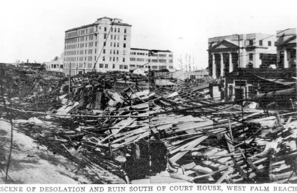
The Devastation of the Okeechobee Hurricane


The aftermath in West Palm Beach
The Okeechobee Hurricane or, in Puerto Rico, Hurricane San Felipe Segundo, occurred in September of 1928. The hurricane made landfall in the Leeward Islands, Guadeloupe, Puerto Rico, the Bahamas and the state of Florida. The Okeechobee Hurricane was at different times a category three, four and five hurricane as it made its destructive path through these locations. The damage caused by this hurricane was at the time estimated to be one hundred million dollars. By today’s standards that would be equal to one billion dollars. A total of 4,078 people or more perished as a direct result of the storm.

The Okeechobee Hurricane was first spotted 900 miles east of Guadeloupe on September 10, 1928. Two days later, on September 12, the hurricane struck the island chain as a category three. The storm caused around 1,200 deaths in Guadeloupe and major property damage. The hurricane then hit the Leeward Islands causing 45 deaths. The damage to crops and property was devastating.

The very next day, the hurricane was at a category five when it made landfall in Puerto Rico. Winds were reported around 160 miles an hour on the island. Around 36 hours before the storm hit, the residents were warned of the danger. They were able to prepare, so loss of life was comparably low with only 300 fatalities. Hurricane Okeechobee was responsible for 50 million dollars (500 million dollars today) worth of damage in Puerto Rico. Several hundred thousand people on the island lost their homes.

The hurricane then moved across the Bahamas as a category four. In the Bahamas, residents were also prepared. There was not a single fatality on the island. Though, 18 people went missing when their sailboat was lost at sea. They are presumed dead.

On September 16, Hurricane Okeechobee made landfall in the state of Florida as a category four. The results were devastating. The eye of the storm passed over Palm Beach County and went straight for Lake Okeechobee. Most of the damage sustained on the Florida coast was in the area of Palm Beach, but loss of life in the area was minimal. There were only 26 fatalities. The population near Lake Okeechobee would not be nearly as lucky.

When the hurricane finally hit Lake Okeechobee winds were around 140 miles per hour. As the winds blew southward across the lake, a storm surge overflowed a dike on its southern edge. This resulted in floods covering hundreds of square miles of farming land and communities. A smaller flood on the northern part of the lake occurred a little later, when the dikes there crumbled.

Many of the bodies of the deceased were lost as floodwaters poured into the Everglades. The floodwaters remained for some weeks, so it was very difficult for relief workers to recover and bury the dead. Eventually mass graves were dug for the bodies, but after a few days even that was not enough. The bodies began to decay in the Florida sun, so survivors were forced to burn the dead.

All told, 2,500 people or more were killed in Florida that fateful day. Around 1,100 of them were buried in one grave in the Port Mayaca Cemetery. The hurricane caused 25 million dollars(250 million dollars today) worth of property damage in Florida.

After leaving Lake Okeechobee, the hurricane moved northeast over Florida and into Georgia and the Carolinas causing only minimal damage in these places. In the aftermath of the hurricane, it became apparent to authorities that flood control on Lake Okeechobee needed to be brought up to par. Building codes were also changed in the hopes that future hurricanes would not cause such extensive damage.

Sources

Doup, Liz, 1928-Okeechobee, Sun-Sentinel, September 11, 1988

Wikipedia, Okeechobee Hurricane, retrieved 6/5/06, wikipedia.org/wiki/Okeechobee_Hurricane

Sunday, October 2, 2016

The 1925 Tri-State Tornado


Aftermath in Griffin, Indiana
The 1925 Tri-State Tornado was the single most deadly tornado in United States history. This massive cyclone ripped through parts of southeastern Missouri, southern Illinois and southwestern Indiana. Today, most experts believe that the Tri-State Tornado was a five on the Fujita Scale, with winds between 261 and 318 miles per hour. It traveled a total of 219 miles, giving it the longest recorded tornado track in the entire world.

The Tri-State Tornado started off in the Ozark Mountains near Ellington, Missouri at 1:01 p.m. on March 18, 1925. At the time, weather forecasters were not allowed to mention tornados in their warnings, and really forecasting a tornado was impossible. Even in recent years, tornados are unpredictable. However, today we are at least allowed to hear speculations of a forming tornado and decide if we want to take shelter. In 1925, this wasn’t an option. So, as the tornado was forming in the Ozarks and getting ready to race across three states at average speeds of between 56 and 73 miles per hour, people were complacently going about their day.

Fourteen minutes after the Tri-State Tornado formed, it was in Annapolis, Missouri. It destroyed 90% of the town and killed several citizens. It then moved across the farmlands of southeastern Missouri and across the Mississippi River. It did the most damage in Illinois. It hit town after town, destroying homes, businesses and vehicles, uprooting trees and killing citizens. The tornado killed 243 people in Murphysboro alone. It is estimated that the tornado averaged 3/4 of a mile wide, but was up to a mile wide at times.

After wreaking havoc in Illinois, the Tri-State Tornado moved into Indiana. It broke up twelve minutes after destroying a quarter of the town of Princeton, Indiana. In its wake were utterly devastated towns. Schools were destroyed with children still inside them. Houses filled with their occupants were moved across the land. Rescue workers dug through rubble to search for survivors for days in some places. There were fires, power outages and shattered families.

The Tri-State Tornado claimed an astounding 695 lives. More than two thousand people were injured by the storm and roughly fifteen thousand homes were destroyed. Since the time of the Tri-State Tornado, the ban on using the word tornado in weather forecasting has been lifted. Awareness of these dangerous storms has increased exponentially. Therefore, people are able to prepare for them. Nonetheless, it is very difficult and, at times, impossible to predict a tornado. Another tornado of this magnitude in the area could still be disastrous.

Monday, September 26, 2016

The Alnwick Poison Gardens

Alnwick Gardens
Photo by xlibber

The Alnwick Gardens are a group of public gardens attached to Alnwick Castle in Northumberland. The castle itself is the second largest in Great Britain. One of the gardens that helps make up the Alnwick Gardens is the Alnwick Poison Garden. This garden boasts some of the world's most dangerous plants, hence the name.

The history of the Alnwick Gardens goes back to 1750. The modern gardens were designed after a long period of neglect. The current Duchess of Northumberland decided to revamp the gardens when she became mistress of Alnwick Castle. The project began around 2000, but she did not begin the Poison Garden until five years later. The Duchess wanted a garden that was filled with narcotic, poisonous and deadly plants. The initial design included some medicinal plants, but she had them removed to maintain the concept of the Poison Garden.

The Duchess of Northumberland had father and son garden designers Jacques and Peter Wirtz design the modern Alnwick Gardens. Besides the Poison Garden, there is the Rose Garden, the Tree House, the Serpent Garden, the Ornamental Garden, the Bamboo Labyrinth and more. The Poison Garden has arguably the most socially significant purpose of all the Alnwick Gardens. Guests who visit the Alnwick Poison Garden are led by guides who teach them about the plants and about drug abuse prevention. The drug abuse prevention message stems from the plants that reside in the Poison Garden.

The plants that grow in the Alnwick Poison Garden could be used to make an array of illegal narcotics. There are poppies, which are used to make opium. There is Atropa belladonna, also known as deadly nightshade, which is famous for its use as a poison. Belladonna is also a hallucinogenic. Cocoa also grows in the Poison Garden. Cocoa sounds like a lovely plant, but it is actually used to make cocaine. Strychnos nux-vomica is another deadly plant, which is used to make strychnine. Also included are hemlock, cannabis and more.

The Poison Garden at Alnwick Gardens is on around the clock surveillance for the safety of the public and would-be thieves. Some of the plants are even kept in specially fenced areas to avoid accidental poisoning or theft of the plants for use in making narcotics. The message at the Poison Garden is anti-drug, so it is of the utmost importance that the plants there be used to educate the public, not harm people.

Source

Alnwick Garden, retrieved 12/2/10

Monday, September 12, 2016

See a Night Sky Underground at New Zealand's Glowworm Caves


Intricate sign at the caves
Photo by A.Aruninta

The Glowworm Caves, or the Waitomo Caves, are amazing natural wonders located in Waitomo on North Island in New Zealand. There is a series of them with millions of glowing larvae, pupae and bugs populating their ceilings. Visitors liken the effect of these glowing creatures to that of a particularly starry night sky. In some spots, you can see glowing dots on strands that hang from above, almost like icicle Christmas lights.

The little bugs, larvae and pupae that are responsible for the decor of the Glowworm Caves are known Arachnocampa luminosa, New Zealand fungus gnats or, less commonly, glowing spider bugs. These bugs go through four basic life stages. They begin as eggs, which hatch to become larvae (during which time they molt four times), which in turn pupate. Then comes the adult. New Zealand fungus gnats begin glowing when they reach the larval stage of their development.

Arachnocampa luminosa larvae spend their days hiding in cracks and crevices in the Glowworm Caves. At night, they come out and hide in little silk tunnels they have constructed. These silk tunnels are for catching prey. They are also used as a dwelling of sorts during the pupal stage of their development. New Zealand fungus gnats spend about three weeks as eggs, six to twelve months as larvae and about twelve days as pupae. Adults come out of the pupal stage unable to eat. They have no mouths. They will only survive long enough to procreate. For the male Arachnocampa luminosa, this will be between three and five days. The female will only survive one or two days. After laying her eggs, she will sometimes stop glowing, always dying shortly thereafter.

There is no shortage of New Zealand fungus gnats in New Zealand. However, the Glowworm Caves are the most popular places to view these bioluminescent bugs. The darkness of the caves makes them a perfect place to witness the glow of the Arachnocampa luminosa.

There are literally hundreds of guided tours available for visitors to the Glowworm Caves. The caves may be entered on foot or via the Waitomo River in a raft or canoe.

Sources

New Zealand Fungus Gnat (NZ Glowworm), retrieved 9/12/16